IMAGES TAKEN NEAR TO
Hoole Lane, PRESTON, PR3 0LN
Introduction
This page details the photographs taken nearby to Hoole Lane, PR3 0LN by members of the Geograph project.
The Geograph project started in 2005 with the aim of publishing, organising and preserving representative images for every square kilometre of Great Britain, Ireland and the Isle of Man.

There are currently over 7.5m images from over14,400 individuals and you can help contribute to the project by visiting https://www.geograph.org.uk
Image Map
Images are licensed for reuse under creativecommons.org/licenses/by-sa/2.0
Notes
- Clicking on the map will re-center to the selected point.
- The higher the marker number, the further away the image location is from the centre of the postcode.
Image Listing (8 Images Found)
Images are licensed for reuse under creativecommons.org/licenses/by-sa/2.0
Image
Details
Distance
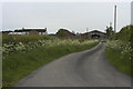
2
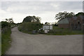
Entrance to Manor House Farm and Fishery
Image: © Tom Richardson
Taken: 25 May 2009
0.13 miles
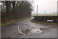
3
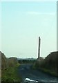
Track between Hoole lane and Shentys Farm
Image: © Peter Bond
Taken: 15 Jan 2012
0.16 miles
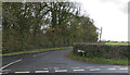
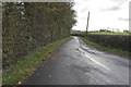
5
Hoole Lane
The junction of Hoole Lane, the turn off to Manor House Farm Fishery.
Image: © Keith Wright
Taken: 30 Dec 2005
0.20 miles
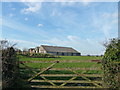
7
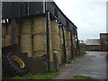
Footpath through Brook Farm
Past large bales of straw stored in an open-sided barn.
Image: © Karl and Ali
Taken: 9 Oct 2011
0.21 miles