IMAGES TAKEN NEAR TO
Island Lane, PRESTON, PR3 0LB
Introduction
This page details the photographs taken nearby to Island Lane, PR3 0LB by members of the Geograph project.
The Geograph project started in 2005 with the aim of publishing, organising and preserving representative images for every square kilometre of Great Britain, Ireland and the Isle of Man.

There are currently over 7.5m images from over14,400 individuals and you can help contribute to the project by visiting https://www.geograph.org.uk
Image Map
Images are licensed for reuse under creativecommons.org/licenses/by-sa/2.0
Notes
- Clicking on the map will re-center to the selected point.
- The higher the marker number, the further away the image location is from the centre of the postcode.
Image Listing (4 Images Found)
Images are licensed for reuse under creativecommons.org/licenses/by-sa/2.0
Image
Details
Distance
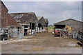
2
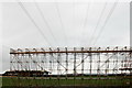
Line Fettling
Major work on overhead power supply
Image: © Bob Jenkins
Taken: 5 Mar 2009
0.10 miles
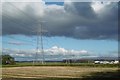
3
Island Wood
And starlings.. presumably the island was once the slightly higher ground set in marshland.
Image: © Richard Webb
Taken: 23 Oct 2016
0.11 miles
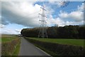
4
Winmarleigh Moss
Power lines cross low lying former marshland in this view from slightly elevated ground on Island Lane.
Image: © Richard Webb
Taken: 23 Oct 2016
0.25 miles