IMAGES TAKEN NEAR TO
Longmoor Lane, PRESTON, PR3 0JB
Introduction
This page details the photographs taken nearby to Longmoor Lane, PR3 0JB by members of the Geograph project.
The Geograph project started in 2005 with the aim of publishing, organising and preserving representative images for every square kilometre of Great Britain, Ireland and the Isle of Man.

There are currently over 7.5m images from over14,400 individuals and you can help contribute to the project by visiting https://www.geograph.org.uk
Image Map (Loading...)


Getting Data...Please wait
Leaflet Map data © OpenStreetMap
Images are licensed for reuse under creativecommons.org/licenses/by-sa/2.0
Notes
- Clicking on the map will re-center to the selected point.
- The higher the marker number, the further away the image location is from the centre of the postcode.
Image Listing (14 Images Found)
Images are licensed for reuse under creativecommons.org/licenses/by-sa/2.0
Image
Details
Distance
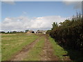
2
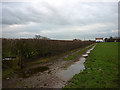
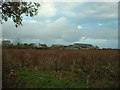
The footpath north of Gibson's Farm
A muddy farm track soon to become a muddy plodge through wet pastures. The big wind turbine of the Dewlay dairy is visible over the hedge.
Image: © Karl and Ali
Taken: 27 Dec 2011
0.03 miles
4
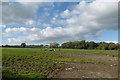
Gibson's Farm, Nateby
Looking east, across a marshy field
Image: © David Medcalf
Taken: 4 Dec 2005
0.07 miles
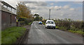
6
Heifers, Longmoor Lane
Dairy farming country with a lot of cattle now indoors for the season.
Image: © Richard Webb
Taken: 23 Oct 2016
0.12 miles
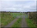
8
Track to Gibson's Farm
The farm track is also a public footpath.
Image: © Bob Jenkins
Taken: 4 Oct 2009
0.16 miles