IMAGES TAKEN NEAR TO
Goose Lane, PR3 0FY
Introduction
This page details the photographs taken nearby to Goose Lane, PR3 0FY by members of the Geograph project.
The Geograph project started in 2005 with the aim of publishing, organising and preserving representative images for every square kilometre of Great Britain, Ireland and the Isle of Man.

There are currently over 7.5m images from over14,400 individuals and you can help contribute to the project by visiting https://www.geograph.org.uk
Image Map
Images are licensed for reuse under creativecommons.org/licenses/by-sa/2.0
Notes
- Clicking on the map will re-center to the selected point.
- The higher the marker number, the further away the image location is from the centre of the postcode.
Image Listing (14 Images Found)
Images are licensed for reuse under creativecommons.org/licenses/by-sa/2.0
Image
Details
Distance
4
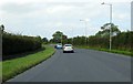
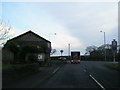
The A6 heading to Lancaster
The A6 bypassing Garstang is called the Preston Lancaster New Road.
Image: © Steve Daniels
Taken: 27 Aug 2014
0.06 miles
5
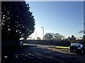
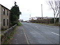
Private car park alongside Garstang Road
Image: © Steve Fareham
Taken: 10 Dec 2013
0.11 miles
6
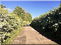
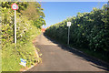
No Way Through
The end of the lane has been blocked by bollards to prevent vehicles from using it as a short-cut between Garstang Road and the A6 (Preston Lancaster Road).
Image: © David Dixon
Taken: 11 May 2019
0.11 miles
7
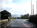
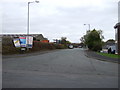
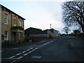
Junction of B6430 and A6 roads.
South of Garstang.
Image: © James Denham
Taken: 27 Oct 2008
0.13 miles
9
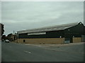
Brockholes Arms Auction Mart
Formerly the Garstang Cattle Market, but now serving a wider range of auctions.
Image: © David Medcalf
Taken: 3 Oct 2005
0.15 miles