IMAGES TAKEN NEAR TO
Baylton Drive, PRESTON, PR3 0EA
Introduction
This page details the photographs taken nearby to Baylton Drive, PR3 0EA by members of the Geograph project.
The Geograph project started in 2005 with the aim of publishing, organising and preserving representative images for every square kilometre of Great Britain, Ireland and the Isle of Man.

There are currently over 7.5m images from over14,400 individuals and you can help contribute to the project by visiting https://www.geograph.org.uk
Image Map
Images are licensed for reuse under creativecommons.org/licenses/by-sa/2.0
Notes
- Clicking on the map will re-center to the selected point.
- The higher the marker number, the further away the image location is from the centre of the postcode.
Image Listing (15 Images Found)
Images are licensed for reuse under creativecommons.org/licenses/by-sa/2.0
Image
Details
Distance
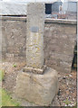
2
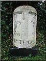
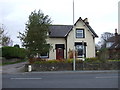
Old Milestone by the B6430, Garstang Road, Catterall Parish
Metal plate attached to stone post by the B6430 (was A6), in parish of CATTERALL (WYRE District), Garstang Road; opposite No. 81 Claughton on Brock, near Joe Lane Bus Stop, between path and hedge, near to post box and bus stop, on West side of road. Garstang flowing text, erected by the Preston and Garstang turnpike trust in the 19th century.
Inscription reads:-
: To / Garstang / 1¾ / Miles : : CATTERALL : : To / Preston / 9 / Miles :
Grade II listed
List Entry Number: 1072921 https://historicengland.org.uk/listing/the-list/list-entry/1072921
Milestone Society National ID: LA_PSGS09.
Image: © A Rosevear
Taken: 14 Jan 2004
0.16 miles
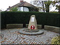
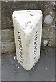
4
Old Wayside Cross by Joe Lane off the A6
Catterall Cross, old base by the A6, in parish of Catterall (Wyre District), Joe Lane, re-erected at roadside against stone wall near farm. On boundary of Catterall and Claughton parishes. Previous location was on the A6 at SD492426.
Grade II listed.
List Entry Number: 1442825 https://historicengland.org.uk/listing/the-list/list-entry/1442825
To be surveyed
Milestone Society National ID: LAWY_CAT
Image: © Milestone Society
Taken: Unknown
0.18 miles
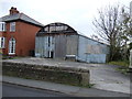
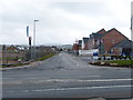
6
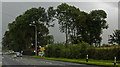
The A6 by Catterall Lodge Farm
The A6 bypassing Garstang is called the Preston Lancaster New Road.
Image: © Steve Daniels
Taken: 27 Aug 2014
0.18 miles
7
Old Boundary Marker by the B6430, Garstang Road, Catterall Parish
Parish Boundary Marker by the B6430 (was A6), in parish of Catterall (Wyre District), Garstang Road, opposite Joe Lane, in front of No. 85 against wall.
Inscription reads:- : CATTERALL : : CLAUGHTON :
Surveyed
Milestone Society National ID: LA_PSGS08pb
Image: © Milestone Society
Taken: Unknown
0.18 miles
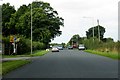
9
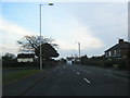
Construction OR Destruction
These were once fields in a rural area
Image: © Malcolm Jones
Taken: 18 Mar 2018
0.19 miles