IMAGES TAKEN NEAR TO
Kilcrash Lane, PRESTON, PR3 0BW
Introduction
This page details the photographs taken nearby to Kilcrash Lane, PR3 0BW by members of the Geograph project.
The Geograph project started in 2005 with the aim of publishing, organising and preserving representative images for every square kilometre of Great Britain, Ireland and the Isle of Man.

There are currently over 7.5m images from over14,400 individuals and you can help contribute to the project by visiting https://www.geograph.org.uk
Image Map
Images are licensed for reuse under creativecommons.org/licenses/by-sa/2.0
Notes
- Clicking on the map will re-center to the selected point.
- The higher the marker number, the further away the image location is from the centre of the postcode.
Image Listing (15 Images Found)
Images are licensed for reuse under creativecommons.org/licenses/by-sa/2.0
Image
Details
Distance
2
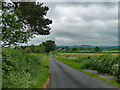
Country road near Forton
Looking north-east towards the thrillingly-named Killcrash.
Image: © Stephen Richards
Taken: 12 Jun 2013
0.08 miles
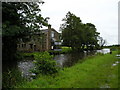
3
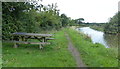
Picnic bench along the Lancaster Canal towpath
This stretch of the canal is between bridges 78 and 79.
Image: © Mat Fascione
Taken: 17 Sep 2018
0.10 miles
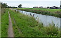
4
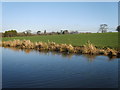
Lancaster Canal
In between Stoney Lane Bridge and Cockerham Road Bridge
Image: © Michael Graham
Taken: 26 Dec 2008
0.10 miles
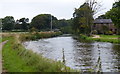
5
Lancaster Canal
On the towpath near Cockerham Road Bridge
Image: © Michael Graham
Taken: 8 Sep 2010
0.16 miles
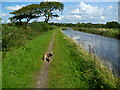
6
Heading north along the Lancaster Canal towpath
Clifton House Farm on the right.
Image: © Mat Fascione
Taken: 17 Sep 2018
0.17 miles
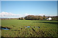
9
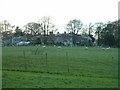
Clifton Hill house
The main buildings are in SD4851. The smaller buildings on the left are in SD4751
Image: © David Medcalf
Taken: 4 Dec 2005
0.20 miles
10
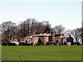
Clifton Hill near Forton
A zoom shot from the footpath further east.
Image: © Karl and Ali
Taken: 2 Apr 2011
0.21 miles