IMAGES TAKEN NEAR TO
Wallace Lane, PRESTON, PR3 0BB
Introduction
This page details the photographs taken nearby to Wallace Lane, PR3 0BB by members of the Geograph project.
The Geograph project started in 2005 with the aim of publishing, organising and preserving representative images for every square kilometre of Great Britain, Ireland and the Isle of Man.

There are currently over 7.5m images from over14,400 individuals and you can help contribute to the project by visiting https://www.geograph.org.uk
Image Map (Loading...)


Getting Data...Please wait
Leaflet Map data © OpenStreetMap
Images are licensed for reuse under creativecommons.org/licenses/by-sa/2.0
Notes
- Clicking on the map will re-center to the selected point.
- The higher the marker number, the further away the image location is from the centre of the postcode.
Image Listing (6 Images Found)
Images are licensed for reuse under creativecommons.org/licenses/by-sa/2.0
Image
Details
Distance
1
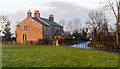
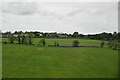
Potters Brook
House at Potters Brook.
Image: © Peter McDermott
Taken: 30 Dec 2014
0.15 miles
3
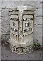
Milestone, Preston Lancaster Road, Forton
A milestone on the turnpike road that became the A6. Distances in Roman numerals, except for the '¾'. Did the Romans use fractions?
Image: © Humphrey Bolton
Taken: 13 May 2007
0.20 miles
5
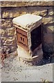
Old Milestone by Tanner's Bridge in Potters Brook
Metal plates attached to stone post by the A6, in parish of Forton (Wyre District), Potter's Brook, by Lane End Cottage, Cockerham Road junction with A6, in tarmac against white garden wall, on West side of road. Lancaster twin iron plate, erected by the Garstang & Heronsyke turnpike trust in the 19th century.
Inscription reads:-
: LANCASTER / VI / MILES : : FORTON : : GARSTANG / IIII ¾ / MILES :
Grade II listed.
List Entry Number: 1318175 https://historicengland.org.uk/listing/the-list/list-entry/1318175
Milestone Society National ID: LA_LAGS06
Image: © A Rosevear
Taken: 8 Sep 2003
0.24 miles