IMAGES TAKEN NEAR TO
Ratcliffe Wharf Lane, PRESTON, PR3 0AJ
Introduction
This page details the photographs taken nearby to Ratcliffe Wharf Lane, PR3 0AJ by members of the Geograph project.
The Geograph project started in 2005 with the aim of publishing, organising and preserving representative images for every square kilometre of Great Britain, Ireland and the Isle of Man.

There are currently over 7.5m images from over14,400 individuals and you can help contribute to the project by visiting https://www.geograph.org.uk
Image Map (Loading...)


Getting Data...Please wait
Leaflet Map data © OpenStreetMap
Images are licensed for reuse under creativecommons.org/licenses/by-sa/2.0
Notes
- Clicking on the map will re-center to the selected point.
- The higher the marker number, the further away the image location is from the centre of the postcode.
Image Listing (9 Images Found)
Images are licensed for reuse under creativecommons.org/licenses/by-sa/2.0
Image
Details
Distance
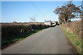
1
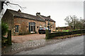
Moorhead Cottage
Situated on Middle Holly, immediately south of the junction with Ratcliffe Wharf Lane in an area where individual dwellings are scattered about within the rather diffuse parish of Forton.
Image: © Andy Waddington
Taken: 23 Dec 2021
0.01 miles
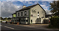
2
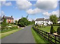
Middle Holly, Forton
This is the old road, before the turnpike road that is now the A6 was built. The house on the right was the Middle Holly Inn and an adjoining cottage. The road name was Middle Holly Lane, but 'Lane' no longer appears on the street signs.
Image: © Humphrey Bolton
Taken: 14 May 2007
0.12 miles
3
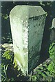
Old Boundary Marker by the A6, Middle Holly, Cabus Parish
Parish Boundary Marker by the A6, in parish of Cabus (Wyre District), Middle Holly, near Middle Holly Road, by bridge over drainage ditch.
Surveyed
Milestone Society National ID: LA_LAGS07pb.
Image: © Milestone Society
Taken: Unknown
0.14 miles
5
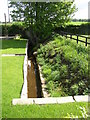
Boundary stream off Middle Holly, Forton / Cabus
This stream is part of the boundary between Forton and Cabus. It has been 'canalised' to form a feature in a garden. Middle Holly is behind the photographer, and the A6 beyond the hedge.
Image: © Humphrey Bolton
Taken: 14 May 2007
0.19 miles
6
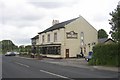
The New Holly Inn, Preston Lancaster Road, Forton
New in the 19C. It faces the early 19C turnpike road, whereas the Bay Horse Inn is on the old road. The Old Holly Inn (Hamilton Arms) is 1km south in Cabus.
Image: © Humphrey Bolton
Taken: 13 May 2007
0.20 miles
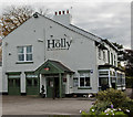
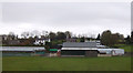
8
The Holly
The Holly alongside the A6.
Image: © Peter McDermott
Taken: 8 Oct 2016
0.21 miles
9
Winder Lane, Forton
There are several Winder gravestones in the village cemetery, suggesting the lane is named after a family.
Image: © Bob Jenkins
Taken: 10 Mar 2009
0.24 miles