IMAGES TAKEN NEAR TO
Whinney Brow, PRESTON, PR3 0AE
Introduction
This page details the photographs taken nearby to Whinney Brow, PR3 0AE by members of the Geograph project.
The Geograph project started in 2005 with the aim of publishing, organising and preserving representative images for every square kilometre of Great Britain, Ireland and the Isle of Man.

There are currently over 7.5m images from over14,400 individuals and you can help contribute to the project by visiting https://www.geograph.org.uk
Image Map (Loading...)


Getting Data...Please wait
Leaflet Map data © OpenStreetMap
Images are licensed for reuse under creativecommons.org/licenses/by-sa/2.0
Notes
- Clicking on the map will re-center to the selected point.
- The higher the marker number, the further away the image location is from the centre of the postcode.
Image Listing (11 Images Found)
Images are licensed for reuse under creativecommons.org/licenses/by-sa/2.0
Image
Details
Distance
1
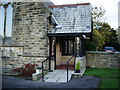
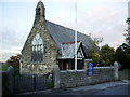
St James' Church, Shireshead, Porch
Image: © Alexander P Kapp
Taken: 13 Nov 2007
0.04 miles
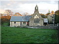
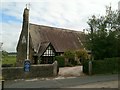
3
St James' Church, Shireshead
The name 'Shireshead' is a very ancient one which may derive from the location of the first church at the apex of gently rising ground. This first building was recorded in 1520, but it was probably erected before that. In the book Northward by Anthony Hewitson, it is said to have had "a more curious or fluctuating career than any other building of the kind in the North". It was occupied for a time in the 17th century by a group of Nonconformists who are said to have been horsewhipped out of the church during Sunday worship by the Duchess of Hamilton. The minister of these worshippers, the Rev. Eleazor Aray, then took charge of the new Independent Chapel, built under the Five Mile Act in 1707. Shireshead St Paul's was built in 1805 on the site of the 1520 church, and Shireshead acquired the status of a parish in 1858. St Paul's is still standing, surrounded by a well-maintained graveyard, even though it was replaced for services in 1889 by a new building, St James's, which is in a more convenient location.
Image: © Rude Health
Taken: 9 Mar 2014
0.05 miles
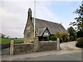
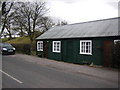
4
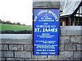
St James' Church, Shireshead, Sign
Image: © Alexander P Kapp
Taken: 13 Nov 2007
0.05 miles
9
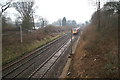
The train takes the strain
Less than a mile from the M6 jam, the London-bound express hurtles by.
Image: © David Long
Taken: 2 Jan 2006
0.15 miles
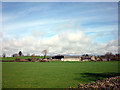
10
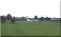
Farmland east of Forton
Brookfield Farm in the distance.
Image: © JThomas
Taken: 7 Nov 2012
0.22 miles