IMAGES TAKEN NEAR TO
Garstang Road, PRESTON, PR2 9XH
Introduction
This page details the photographs taken nearby to Garstang Road, PR2 9XH by members of the Geograph project.
The Geograph project started in 2005 with the aim of publishing, organising and preserving representative images for every square kilometre of Great Britain, Ireland and the Isle of Man.

There are currently over 7.5m images from over14,400 individuals and you can help contribute to the project by visiting https://www.geograph.org.uk
Image Map
Images are licensed for reuse under creativecommons.org/licenses/by-sa/2.0
Notes
- Clicking on the map will re-center to the selected point.
- The higher the marker number, the further away the image location is from the centre of the postcode.
Image Listing (10 Images Found)
Images are licensed for reuse under creativecommons.org/licenses/by-sa/2.0
Image
Details
Distance
4
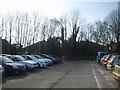
Car Park
At the Royal Preston Hospital. The photograph was taken to try and capture a whirlwind which was blowing around the car park at the time. A faint cloud of dust in front of the yellow sign is all that is revealed but it was a noisy and quite impressive small whirlwind.
Image: © Michael Graham
Taken: 16 Mar 2010
0.17 miles
6
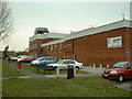
Fulwood Leisure Centre
Adjacent to Fulwood High School
Image: © David Medcalf
Taken: 13 Mar 2006
0.19 miles
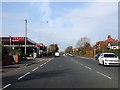
8
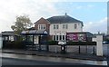
Fulwood Library, on the A6
As seen from the saloon of the no.40 Morecambe-Preston bus.
Image: © David Long
Taken: 30 Dec 2008
0.23 miles
9
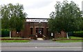
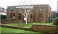
Fulwood Library
Fulwood library was built in 1939 and is a purpose built library, complete with its own air raid shelter.
Image: © Rude Health
Taken: 28 Jul 2013
0.23 miles
10
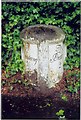
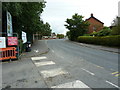
Old Milestone by the A6, Garstang Road, Broughton Parish
The milestone is located by the Harris Orphanage, on the West side of road by the roadside. Parish of Broughton (Preston District). Metal plate attached to stone post, Garstang flowing text design, erected by the Preston & Garstang turnpike trust in the 19th century.
Inscription reads:- To / Garstang / 8¾ / Miles : : To / Preston / 2 Miles
Grade II listed, List Entry Number: 1073527 https://historicengland.org.uk/listing/the-list/list-entry/1073527
Milestone Society National ID: LA_PSGS02
Image: © J Higgins
Taken: 1 May 2009
0.24 miles