IMAGES TAKEN NEAR TO
Brookside Road, PRESTON, PR2 9TS
Introduction
This page details the photographs taken nearby to Brookside Road, PR2 9TS by members of the Geograph project.
The Geograph project started in 2005 with the aim of publishing, organising and preserving representative images for every square kilometre of Great Britain, Ireland and the Isle of Man.

There are currently over 7.5m images from over14,400 individuals and you can help contribute to the project by visiting https://www.geograph.org.uk
Image Map
Images are licensed for reuse under creativecommons.org/licenses/by-sa/2.0
Notes
- Clicking on the map will re-center to the selected point.
- The higher the marker number, the further away the image location is from the centre of the postcode.
Image Listing (13 Images Found)
Images are licensed for reuse under creativecommons.org/licenses/by-sa/2.0
Image
Details
Distance

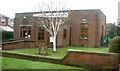
2
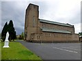
Our Lady & St Edward's Catholic Church
St Anthony's church served the area until the expansion of Fulwood to the west of Garstang Road led to the opening of Our Lady and St Edward's on Marlborough Drive in 1954. The Primary School was not opened until the summer of 1966, the children attending St Anthony's until then, by which time it had had to be built away from the church and on Lightfoot Lane.
Image: © Rude Health
Taken: 28 Jul 2013
0.13 miles
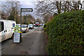
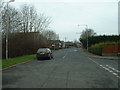
7
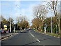
A6 road at junction with Beech Drive
Image: © David Robinson
Taken: 19 Oct 2024
0.21 miles
8
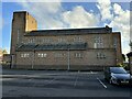
Fulwood Library, on the A6
As seen from the saloon of the no.40 Morecambe-Preston bus.
Image: © David Long
Taken: 30 Dec 2008
0.21 miles
9
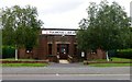
Fulwood Library
Fulwood library was built in 1939 and is a purpose built library, complete with its own air raid shelter.
Image: © Rude Health
Taken: 28 Jul 2013
0.21 miles
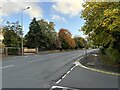
10
Lightfoot Lane, Fulwood
This used to be the major road into the Fylde from north Preston, but now replaced by a new road to service the housing estates of Tanterton and Ingol. Lightfoot Lane has been 'chopped off' - there is a dead end behind the photographer.
Image: © David Medcalf
Taken: 6 Feb 2006
0.22 miles