IMAGES TAKEN NEAR TO
South Drive, PRESTON, PR2 9SR
Introduction
This page details the photographs taken nearby to South Drive, PR2 9SR by members of the Geograph project.
The Geograph project started in 2005 with the aim of publishing, organising and preserving representative images for every square kilometre of Great Britain, Ireland and the Isle of Man.

There are currently over 7.5m images from over14,400 individuals and you can help contribute to the project by visiting https://www.geograph.org.uk
Image Map
Images are licensed for reuse under creativecommons.org/licenses/by-sa/2.0
Notes
- Clicking on the map will re-center to the selected point.
- The higher the marker number, the further away the image location is from the centre of the postcode.
Image Listing (11 Images Found)
Images are licensed for reuse under creativecommons.org/licenses/by-sa/2.0
Image
Details
Distance
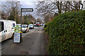
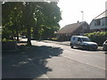
2
A6 road at junction with Beech Drive
Image: © David Robinson
Taken: 19 Oct 2024
0.15 miles
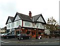
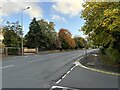
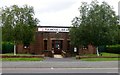
9
Fulwood Library, on the A6
As seen from the saloon of the no.40 Morecambe-Preston bus.
Image: © David Long
Taken: 30 Dec 2008
0.23 miles
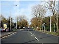
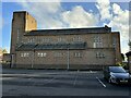
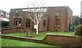
10
Fulwood Library
Fulwood library was built in 1939 and is a purpose built library, complete with its own air raid shelter.
Image: © Rude Health
Taken: 28 Jul 2013
0.23 miles