IMAGES TAKEN NEAR TO
Haywood Close, PRESTON, PR2 9PJ
Introduction
This page details the photographs taken nearby to Haywood Close, PR2 9PJ by members of the Geograph project.
The Geograph project started in 2005 with the aim of publishing, organising and preserving representative images for every square kilometre of Great Britain, Ireland and the Isle of Man.

There are currently over 7.5m images from over14,400 individuals and you can help contribute to the project by visiting https://www.geograph.org.uk
Image Map
Images are licensed for reuse under creativecommons.org/licenses/by-sa/2.0
Notes
- Clicking on the map will re-center to the selected point.
- The higher the marker number, the further away the image location is from the centre of the postcode.
Image Listing (9 Images Found)
Images are licensed for reuse under creativecommons.org/licenses/by-sa/2.0
Image
Details
Distance
1
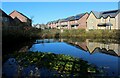
Redwing Estate, Preston
Looking across a pond from Eastway to the recently erected Redwing Estate
Image: © Chris Heaton
Taken: 19 Nov 2022
0.10 miles
2
Bridleway heading towards the Redwing Estate
Image: © Chris Heaton
Taken: 19 Nov 2022
0.15 miles

4
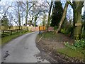
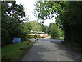
Entrance to Durton House
The entrance to Durton House off D'Urton Lane.
Image: © Rude Health
Taken: 15 Apr 2013
0.20 miles
5
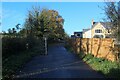
Midgery Lane
Midgery Lane is now used a lot by cyclists as it is part of the Preston Guild Wheel which opened in the summer of 2012.
Image: © Rude Health
Taken: 15 Apr 2013
0.21 miles
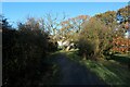
7
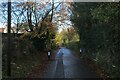
Midgery Lane
Heading northwest from an industrial estate to D'Urton Lane
Image: © Chris Heaton
Taken: 19 Nov 2022
0.22 miles
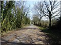
8
D'Urton Lane
Now a quiet backwater and part of the Preston Guild Wheel cycle route.
Image: © Chris Heaton
Taken: 19 Nov 2022
0.22 miles
9
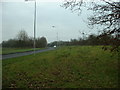
Eastway, Preston
Built to service the Central Lancashire New Town.
Image: © David Medcalf
Taken: 6 Feb 2006
0.23 miles