IMAGES TAKEN NEAR TO
Larchgate, PRESTON, PR2 9AF
Introduction
This page details the photographs taken nearby to Larchgate, PR2 9AF by members of the Geograph project.
The Geograph project started in 2005 with the aim of publishing, organising and preserving representative images for every square kilometre of Great Britain, Ireland and the Isle of Man.

There are currently over 7.5m images from over14,400 individuals and you can help contribute to the project by visiting https://www.geograph.org.uk
Image Map
Images are licensed for reuse under creativecommons.org/licenses/by-sa/2.0
Notes
- Clicking on the map will re-center to the selected point.
- The higher the marker number, the further away the image location is from the centre of the postcode.
Image Listing (14 Images Found)
Images are licensed for reuse under creativecommons.org/licenses/by-sa/2.0
Image
Details
Distance
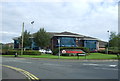
1
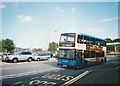
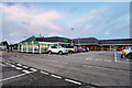
Bus in ASDA car park, Sherwood
Preston Bus 193, a Dennis Trident/East Lancs Lolyne, proceeds through the car park at the outer terminus of route 23 from Preston city centre via Plungington Road and Fulwood. It is carrying route branding for routes 33 and 35 to Tanterton.
Image: © Richard Vince
Taken: 23 Sep 2006
0.09 miles