IMAGES TAKEN NEAR TO
Fulwood Hall Lane, PRESTON, PR2 8DA
Introduction
This page details the photographs taken nearby to Fulwood Hall Lane, PR2 8DA by members of the Geograph project.
The Geograph project started in 2005 with the aim of publishing, organising and preserving representative images for every square kilometre of Great Britain, Ireland and the Isle of Man.

There are currently over 7.5m images from over14,400 individuals and you can help contribute to the project by visiting https://www.geograph.org.uk
Image Map
Images are licensed for reuse under creativecommons.org/licenses/by-sa/2.0
Notes
- Clicking on the map will re-center to the selected point.
- The higher the marker number, the further away the image location is from the centre of the postcode.
Image Listing (6 Images Found)
Images are licensed for reuse under creativecommons.org/licenses/by-sa/2.0
Image
Details
Distance
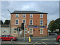
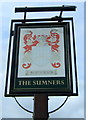
2
The Royal Garrison - Closed & Boarded
Image: © Anthony Parkes
Taken: 10 Mar 2012
0.20 miles
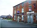
3
The Royal Garrison
Former public house, Fulwood.
Image: © JThomas
Taken: 1 Oct 2016
0.22 miles
5
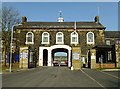
Entrance To Fulwood Barracks
Fulwood Barracks has been the home of the Queen's Lancashire Regiment, and other regiments, and is the site of the Queen's Lancashire Regiment Museum. Fulwood Barracks was built in 1848. According to the Queens Lancashire Regiment Museum website it is the most complete example of mid-Victorian military architecture in the country. It was built as part of a chain of seven barracks to quell the Chartists.
Image: © Rude Health
Taken: 18 Feb 2013
0.24 miles