IMAGES TAKEN NEAR TO
Golf View, PRESTON, PR2 7EL
Introduction
This page details the photographs taken nearby to Golf View, PR2 7EL by members of the Geograph project.
The Geograph project started in 2005 with the aim of publishing, organising and preserving representative images for every square kilometre of Great Britain, Ireland and the Isle of Man.

There are currently over 7.5m images from over14,400 individuals and you can help contribute to the project by visiting https://www.geograph.org.uk
Image Map
Images are licensed for reuse under creativecommons.org/licenses/by-sa/2.0
Notes
- Clicking on the map will re-center to the selected point.
- The higher the marker number, the further away the image location is from the centre of the postcode.
Image Listing (4 Images Found)
Images are licensed for reuse under creativecommons.org/licenses/by-sa/2.0
Image
Details
Distance
1
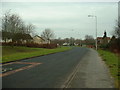
Tanterton Hall Road, Tanterton
Created to serve new housing estates in north Preston.
Image: © David Medcalf
Taken: 6 Feb 2006
0.04 miles
3
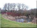
Duck pond at Tanterton
A strange - and stagnant - relic in the middle of brash new housing estates. The nanny state has not yet drained it or fenced it off.
Image: © David Medcalf
Taken: 6 Feb 2006
0.16 miles
4
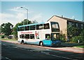
Bus on Tanterton Hall Road, Tanterton
Preston Bus 184, a Dennis Trident/East Lancs Lolyne, stands at the nominal terminus of route 33 to Preston city centre. It is carrying route branding for routes 22 and 23 to Fulwood and Sherwood, and therefore seems to have swapped places with Image (seen earlier the same day).
Image: © Richard Vince
Taken: 23 Sep 2006
0.20 miles