IMAGES TAKEN NEAR TO
Turnfield, PRESTON, PR2 7DH
Introduction
This page details the photographs taken nearby to Turnfield, PR2 7DH by members of the Geograph project.
The Geograph project started in 2005 with the aim of publishing, organising and preserving representative images for every square kilometre of Great Britain, Ireland and the Isle of Man.

There are currently over 7.5m images from over14,400 individuals and you can help contribute to the project by visiting https://www.geograph.org.uk
Image Map
Images are licensed for reuse under creativecommons.org/licenses/by-sa/2.0
Notes
- Clicking on the map will re-center to the selected point.
- The higher the marker number, the further away the image location is from the centre of the postcode.
Image Listing (10 Images Found)
Images are licensed for reuse under creativecommons.org/licenses/by-sa/2.0
Image
Details
Distance

6
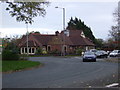
The Guild Merchant pub
On the roundabout, Tag Lane, Preston
Image: © JThomas
Taken: 1 Nov 2014
0.15 miles
7
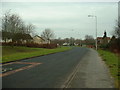
Tanterton Hall Road, Tanterton
Created to serve new housing estates in north Preston.
Image: © David Medcalf
Taken: 6 Feb 2006
0.19 miles