IMAGES TAKEN NEAR TO
Halton Place, PRESTON, PR2 6SR
Introduction
This page details the photographs taken nearby to Halton Place, PR2 6SR by members of the Geograph project.
The Geograph project started in 2005 with the aim of publishing, organising and preserving representative images for every square kilometre of Great Britain, Ireland and the Isle of Man.

There are currently over 7.5m images from over14,400 individuals and you can help contribute to the project by visiting https://www.geograph.org.uk
Image Map
Images are licensed for reuse under creativecommons.org/licenses/by-sa/2.0
Notes
- Clicking on the map will re-center to the selected point.
- The higher the marker number, the further away the image location is from the centre of the postcode.
Image Listing (19 Images Found)
Images are licensed for reuse under creativecommons.org/licenses/by-sa/2.0
Image
Details
Distance
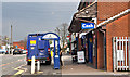
1
The former station on the railway line
Originally a mid-19th century station house and booking office on the Longridge Railway, and Grade II listed https://britishlistedbuildings.co.uk/101207285-former-railway-station-on-former-longridge-railway-preston & https://historicengland.org.uk/listing/the-list/list-entry/1207285 in 1991. It's now a private house.
Image: © Richard Law
Taken: 22 May 2019
0.04 miles
2
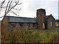
Brookfield Methodist Church
Ribbleton Reality.
The area of Ribbleton is one of the least picturesque areas of Preston. This photo shows Brookfield Methodist Church, Oakworth Avenue, Ribbleton, PR2 6SQ, which closed in 2006.
Image: © Rude Health
Taken: 8 Dec 2012
0.06 miles
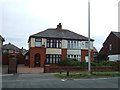
3
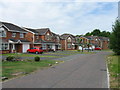
New houses, corner of Watling Street Road and Gamull Lane
I rather suspect this new development takes the place of Image, of which I saw no sign in 2019.
Image: © Richard Law
Taken: 22 May 2019
0.06 miles
4
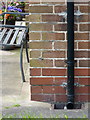
OS benchmark - no 2 Oakworth Avenue
An OS cutmark on the north wall of a house on Oakworth Avenue, originally levelled in 1961 at 52.566m above Ordnance Datum Newlyn.
Image: © Richard Law
Taken: 22 May 2019
0.09 miles
5
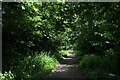
On the Former Preston/Longridge Railway
Closed to passengers as far back as 1930 - and freight in 1967.
Now converted to leisure use for cyclists and walkers - forming a green tunnel as this point.
Image: © Chris Heaton
Taken: 11 Jun 2022
0.10 miles
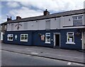
6
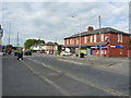
Shops and houses, Longridge Road
I say 'shops' as if you can buy useful goods here... in reality it's actually a couple of bookies, although the chip shop on the left has actual food for sale.
Image: © Richard Law
Taken: 22 May 2019
0.11 miles
8
Casing a cash heist
I was taking an innocent photo of Gamull shops when the man with the money walked into the shot. I realised how easily this could be misinterpreted.
Image: © Ian Greig
Taken: 28 Mar 2014
0.12 miles
9
The Gamull, Longridge Road, Ribbleton, Preston
Viewed in June 2023. The pub reopened on May 26th 2023 after a £300,000 refurbishment.
The pub was originally known as the Fulwood & Railway.
Image: © Jaggery
Taken: 7 Jun 2023
0.12 miles