IMAGES TAKEN NEAR TO
Bay Road, PRESTON, PR2 6NN
Introduction
This page details the photographs taken nearby to Bay Road, PR2 6NN by members of the Geograph project.
The Geograph project started in 2005 with the aim of publishing, organising and preserving representative images for every square kilometre of Great Britain, Ireland and the Isle of Man.

There are currently over 7.5m images from over14,400 individuals and you can help contribute to the project by visiting https://www.geograph.org.uk
Image Map
Images are licensed for reuse under creativecommons.org/licenses/by-sa/2.0
Notes
- Clicking on the map will re-center to the selected point.
- The higher the marker number, the further away the image location is from the centre of the postcode.
Image Listing (6 Images Found)
Images are licensed for reuse under creativecommons.org/licenses/by-sa/2.0
Image
Details
Distance
1
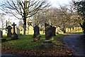
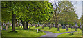
Preston Cemetery
The cemetery is on two sites each side of Miller Road. This is just inside the gates of the larger site.
Image: © Bill Boaden
Taken: 18 Feb 2012
0.09 miles
2
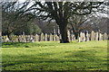
Preston Cemetery
The trees increase the sense of space by giving glimpses of areas beyond. The arrangement is far from just regimented rows, although there is clearly order.
Image: © Bill Boaden
Taken: 18 Feb 2012
0.10 miles
4
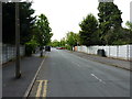
SE along Woodlands Avenue
A fairly nondescript residential street in urban Preston.
Image: © Richard Law
Taken: 22 May 2019
0.21 miles
5
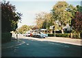
Bus on Ribbleton Avenue, Ribbleton
Stagecoach Lancashire 20475, one of the huge quantity of Volvo B10M/Alexander PS buses bought by Stagecoach in the 1990s, pauses at the traffic lights at the Cromwell Road junction while working route 2A from Longridge to Preston.
Image: © Richard Vince
Taken: 23 Sep 2006
0.24 miles
6
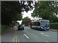
Stagecoach bus on Ribbleton Avenue
Stagecoach Merseyside & South Lancashire 27887 Reg. No. PE13 LTF.
Image: © JThomas
Taken: 24 Sep 2016
0.25 miles