IMAGES TAKEN NEAR TO
Burholme Road, PRESTON, PR2 6HN
Introduction
This page details the photographs taken nearby to Burholme Road, PR2 6HN by members of the Geograph project.
The Geograph project started in 2005 with the aim of publishing, organising and preserving representative images for every square kilometre of Great Britain, Ireland and the Isle of Man.

There are currently over 7.5m images from over14,400 individuals and you can help contribute to the project by visiting https://www.geograph.org.uk
Image Map
Images are licensed for reuse under creativecommons.org/licenses/by-sa/2.0
Notes
- Clicking on the map will re-center to the selected point.
- The higher the marker number, the further away the image location is from the centre of the postcode.
Image Listing (4 Images Found)
Images are licensed for reuse under creativecommons.org/licenses/by-sa/2.0
Image
Details
Distance
2
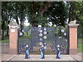
Entrance to Grange Park
In February 1996, Chrysalis Arts was commissioned by Preston Borough Council to produce artworks at the entrance to Grange Park. The project was developed from the outset on the principle of collaborative work practice with the Council's Architects Division and with the involvement of local community groups and schools through workshops led by artists from Chrysalis Arts www.chrysalisarts.org.uk . Around 60 individuals from six local schools and four local groups were involved in the creative process. (Part of a circular walk around Preston – continues at Image)
Image: © Patrick
Taken: 9 Sep 2007
0.22 miles

4
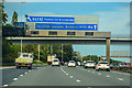
Preston : M6 Motorway
The M6 Motorway between Junction 31 (Ribble Valley Interchange) and Junction 31A.
Image: © Lewis Clarke
Taken: 23 Sep 2019
0.25 miles