IMAGES TAKEN NEAR TO
Station Road, LEYLAND, PR26 9RP
Introduction
This page details the photographs taken nearby to Station Road, PR26 9RP by members of the Geograph project.
The Geograph project started in 2005 with the aim of publishing, organising and preserving representative images for every square kilometre of Great Britain, Ireland and the Isle of Man.

There are currently over 7.5m images from over14,400 individuals and you can help contribute to the project by visiting https://www.geograph.org.uk
Image Map
Images are licensed for reuse under creativecommons.org/licenses/by-sa/2.0
Notes
- Clicking on the map will re-center to the selected point.
- The higher the marker number, the further away the image location is from the centre of the postcode.
Image Listing (74 Images Found)
Images are licensed for reuse under creativecommons.org/licenses/by-sa/2.0
Image
Details
Distance
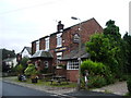
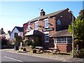
2
House on the corner
On the edge of Croston village, on the Southport road, this house seems to me, that in a previous life it was a shop.
Image: © Phil and Juliette Platt
Taken: 3 Jun 2011
0.07 miles
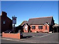
3
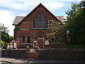
Trinity, Croston - Wesleyan Methodist
Founded before 1894 it closed in 2010.
Image: © Steve Houldsworth
Taken: 20 Jun 2010
0.08 miles
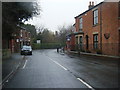
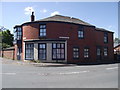
9
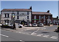
Pub, Ristorante, Pub
In the centre of Croston Village. The Wheatsheaf, An Italian restaurant, and the Lord Nelson
Image: © Phil and Juliette Platt
Taken: 3 Jun 2011
0.12 miles
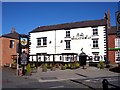
10
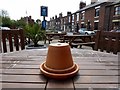
Time for tiffin
In the beer garden at the Wheatsheaf in Croston.
Image: © philandju
Taken: 17 May 2016
0.12 miles