IMAGES TAKEN NEAR TO
The Orchard, LEYLAND, PR26 9HS
Introduction
This page details the photographs taken nearby to The Orchard, PR26 9HS by members of the Geograph project.
The Geograph project started in 2005 with the aim of publishing, organising and preserving representative images for every square kilometre of Great Britain, Ireland and the Isle of Man.

There are currently over 7.5m images from over14,400 individuals and you can help contribute to the project by visiting https://www.geograph.org.uk
Image Map
Images are licensed for reuse under creativecommons.org/licenses/by-sa/2.0
Notes
- Clicking on the map will re-center to the selected point.
- The higher the marker number, the further away the image location is from the centre of the postcode.
Image Listing (22 Images Found)
Images are licensed for reuse under creativecommons.org/licenses/by-sa/2.0
Image
Details
Distance
2
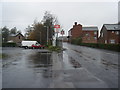
Sign
Old sign on building opposite The De Trafford Arms
Image: © Alexander P Kapp
Taken: 26 Aug 2008
0.16 miles
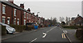
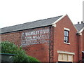
4
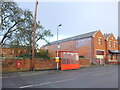
Station Road, Croston
A VR Postbox, a bus stop and a ghost sign that reads "E Walmsley and Son, Corn Miller"
Image: © Gary Rogers
Taken: 18 Feb 2016
0.18 miles
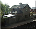
5
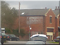
Ghost sign in Croston
Glimpsed from a train at the station, this sign reads "E Walmsley & Son - corn miller".
Image: © Stephen Craven
Taken: 24 Mar 2018
0.19 miles
6
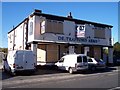
A forlorn De Trafford Arms waits a buyer
Image: © Raymond Knapman
Taken: 20 Oct 2010
0.19 miles
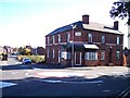
7
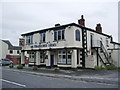
The De Trafford Arms, Station Road, Croston
Image: © Alexander P Kapp
Taken: 26 Aug 2008
0.19 miles
8
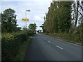
Moor Road, (B5249)
Heading north west towards Croston on National Cycle Route 62.
Image: © JThomas
Taken: 11 Oct 2014
0.20 miles