IMAGES TAKEN NEAR TO
Hawthorne Close, LEYLAND, PR26 8NY
Introduction
This page details the photographs taken nearby to Hawthorne Close, PR26 8NY by members of the Geograph project.
The Geograph project started in 2005 with the aim of publishing, organising and preserving representative images for every square kilometre of Great Britain, Ireland and the Isle of Man.

There are currently over 7.5m images from over14,400 individuals and you can help contribute to the project by visiting https://www.geograph.org.uk
Image Map
Images are licensed for reuse under creativecommons.org/licenses/by-sa/2.0
Notes
- Clicking on the map will re-center to the selected point.
- The higher the marker number, the further away the image location is from the centre of the postcode.
Image Listing (24 Images Found)
Images are licensed for reuse under creativecommons.org/licenses/by-sa/2.0
Image
Details
Distance
1
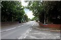
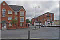
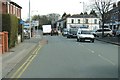
Earnshaw Bridge, Longmeanygate
Recently installed pedestrian-controlled traffic lights on Longmeanygate.
Image: © David Dixon
Taken: 14 Jun 2015
0.04 miles
3
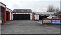
Barry and Wilkinson Garage Services - Leyland
Image: © Anthony Parkes
Taken: 15 Mar 2014
0.06 miles
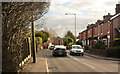
5
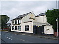
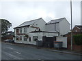
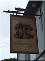
The Tiger
View along Longmeanygate. The Tiger apartments on the left of the scene occupy the site of the former Leyland Tiger pub.
Image: © Gerald McKenna
Taken: 28 May 2011
0.09 miles
9
Traffic lights at the junction of Leyland Lane and Golden Hill Lane
Image: © Ann Cook
Taken: 19 Mar 2011
0.12 miles
10
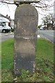
Old Milestone by Leyland Lane, Leyland Parish
Stone post (plate lost) by the UC road (was B5253), in parish of LEYLAND (SOUTH RIBBLE District), Leyland Lane; by No. 13, on grass verge, on East side of road, opposite Hugh Lane. Preston iron plate, erected by the Wigan & Preston (north of Yarrow) turnpike trust in the 19th century.
Inscription once read:-
(TO)
(PRESTON)
(5)
(MILES)
Milestone Society National ID: LA_PSWG05.
Image: © J Higgins
Taken: 1 Oct 2008
0.13 miles