IMAGES TAKEN NEAR TO
Paddock Avenue, LEYLAND, PR26 7LF
Introduction
This page details the photographs taken nearby to Paddock Avenue, PR26 7LF by members of the Geograph project.
The Geograph project started in 2005 with the aim of publishing, organising and preserving representative images for every square kilometre of Great Britain, Ireland and the Isle of Man.

There are currently over 7.5m images from over14,400 individuals and you can help contribute to the project by visiting https://www.geograph.org.uk
Image Map
Images are licensed for reuse under creativecommons.org/licenses/by-sa/2.0
Notes
- Clicking on the map will re-center to the selected point.
- The higher the marker number, the further away the image location is from the centre of the postcode.
Image Listing (13 Images Found)
Images are licensed for reuse under creativecommons.org/licenses/by-sa/2.0
Image
Details
Distance
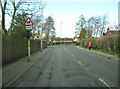
1
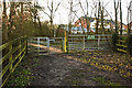
No horses or motorbikes - it's not actually shown as a footpath either
Image: © Ian Greig
Taken: 8 Feb 2013
0.09 miles
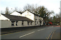
3
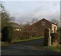
Not quite the right angle
But then I was after the angles of the gable end
Image: © David Long
Taken: 17 Jan 2006
0.10 miles
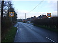
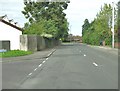
4
Slater Lane at the junction with School Lane
Image: © Ann Cook
Taken: 19 Mar 2011
0.15 miles
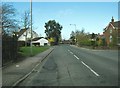
5
Slater Lane approaching the junction with School Lane
This view is taken from the corner of St. James's Gardens.
Image: © Ann Cook
Taken: 26 Aug 2010
0.15 miles
6
Slater Lane at the junction with Lansborough Close
Lansborough Close is on the right. The turning on the left is St. James's Gardens.
Image: © Ann Cook
Taken: 19 Mar 2011
0.20 miles
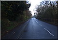
8
Tractor on the B5248 passing the Black Bull
Image: © David Long
Taken: 16 Jan 2006
0.21 miles
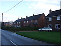
9
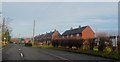
Houses on Ulnes Walton Lane - Moss Side
Image: © Anthony Parkes
Taken: 14 Dec 2013
0.21 miles