IMAGES TAKEN NEAR TO
Huddleston Place, LEYLAND, PR26 6RJ
Introduction
This page details the photographs taken nearby to Huddleston Place, PR26 6RJ by members of the Geograph project.
The Geograph project started in 2005 with the aim of publishing, organising and preserving representative images for every square kilometre of Great Britain, Ireland and the Isle of Man.

There are currently over 7.5m images from over14,400 individuals and you can help contribute to the project by visiting https://www.geograph.org.uk
Image Map
Images are licensed for reuse under creativecommons.org/licenses/by-sa/2.0
Notes
- Clicking on the map will re-center to the selected point.
- The higher the marker number, the further away the image location is from the centre of the postcode.
Image Listing (10 Images Found)
Images are licensed for reuse under creativecommons.org/licenses/by-sa/2.0
Image
Details
Distance
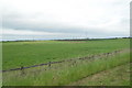
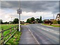
6
Hugh Lane towards High House Farm
Access form Flensburg Way is now blocked to vehicles.
Image: © JThomas
Taken: 25 Oct 2018
0.17 miles
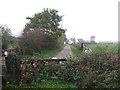
8
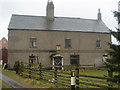
Manor House at Leyland
Date 1700's. It looked derelict but is obviously inhabited as there are geese in the garden. It is surrounded by a new 'executive' housing estate so it looks as though the manor house's land has been sold for development.
Image: © Margaret Clough
Taken: 27 Mar 2006
0.21 miles
10
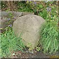
Old Boundary Marker by Leyland Lane, farington Parish
Parish Boundary Marker by the UC road, in parish of Farington (South Ribble District), Outside No 1, Leyland Lane, Earnshaw Bridge.
Surveyed
Milestone Society National ID: LA_PSWG04pb
Image: © Milestone Society
Taken: Unknown
0.24 miles