IMAGES TAKEN NEAR TO
PR26 6AW
Introduction
This page details the photographs taken nearby to PR26 6AW by members of the Geograph project.
The Geograph project started in 2005 with the aim of publishing, organising and preserving representative images for every square kilometre of Great Britain, Ireland and the Isle of Man.

There are currently over 7.5m images from over14,400 individuals and you can help contribute to the project by visiting https://www.geograph.org.uk
Image Map
Images are licensed for reuse under creativecommons.org/licenses/by-sa/2.0
Notes
- Clicking on the map will re-center to the selected point.
- The higher the marker number, the further away the image location is from the centre of the postcode.
Image Listing (27 Images Found)
Images are licensed for reuse under creativecommons.org/licenses/by-sa/2.0
Image
Details
Distance
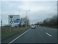
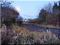
3
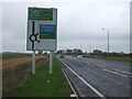
Flensburg Way (B5253), Farington Moss approaching roundabout
Looking north - the road becomes the A582 after the roundabout.
Image: © JThomas
Taken: 25 Oct 2018
0.07 miles
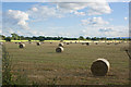
4
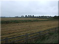
Fields, Farington Moss
Separated by a drain. Flensburg Way (B5253).
Image: © JThomas
Taken: 25 Oct 2018
0.09 miles
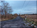
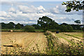
8
Link road from Flensburg Way to Moss Lane
Image: © Alexander P Kapp
Taken: 26 Nov 2010
0.16 miles