IMAGES TAKEN NEAR TO
Roman Way, Longridge Road, PRESTON, PR2 5BB
Introduction
This page details the photographs taken nearby to Roman Way, Longridge Road, PR2 5BB by members of the Geograph project.
The Geograph project started in 2005 with the aim of publishing, organising and preserving representative images for every square kilometre of Great Britain, Ireland and the Isle of Man.

There are currently over 7.5m images from over14,400 individuals and you can help contribute to the project by visiting https://www.geograph.org.uk
Image Map
Images are licensed for reuse under creativecommons.org/licenses/by-sa/2.0
Notes
- Clicking on the map will re-center to the selected point.
- The higher the marker number, the further away the image location is from the centre of the postcode.
Image Listing (6 Images Found)
Images are licensed for reuse under creativecommons.org/licenses/by-sa/2.0
Image
Details
Distance
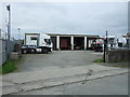
1
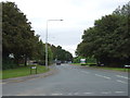
Roman Way
Industrial estate road off Longridge Road (B6243).
Image: © JThomas
Taken: 24 Sep 2016
0.14 miles
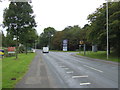
3
Entering Grimsargh Village
Heading north east on the B6243.
Image: © JThomas
Taken: 24 Sep 2016
0.19 miles
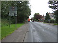
4
Carry On at Your Convenience at Preston Crematorium
Also called "Carry On Round The Bend" outside the UK but also very apt for the Guild Wheel. There is also now a new crossing point for cyclists and walker to the west of the crematorium entrance. This should also help traffic enter and exit the side roads.
Image: © Rude Health
Taken: 19 Jul 2012
0.22 miles
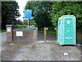
6
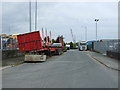
Rough Hey Road
Industrial estate road - looking north west.
Image: © JThomas
Taken: 24 Sep 2016
0.25 miles