IMAGES TAKEN NEAR TO
Claughton Avenue, LEYLAND, PR25 5TP
Introduction
This page details the photographs taken nearby to Claughton Avenue, PR25 5TP by members of the Geograph project.
The Geograph project started in 2005 with the aim of publishing, organising and preserving representative images for every square kilometre of Great Britain, Ireland and the Isle of Man.

There are currently over 7.5m images from over14,400 individuals and you can help contribute to the project by visiting https://www.geograph.org.uk
Image Map
Images are licensed for reuse under creativecommons.org/licenses/by-sa/2.0
Notes
- Clicking on the map will re-center to the selected point.
- The higher the marker number, the further away the image location is from the centre of the postcode.
Image Listing (17 Images Found)
Images are licensed for reuse under creativecommons.org/licenses/by-sa/2.0
Image
Details
Distance
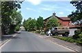
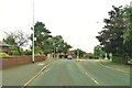
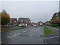
3
Mini-roundabout on Lancaster Lane
Spring Meadow is to the right and Magnolia Drive to the left. Straight ahead is Town Brow.
Image: © Ann Cook
Taken: 20 Dec 2010
0.13 miles
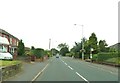
4
A mini-roundabout on Lancaster Lane
Spring Meadow is to the left and Magnolia Drive to the right.
Image: © Ann Cook
Taken: 8 Sep 2012
0.13 miles
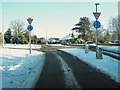
6
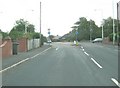
Mini-roundabout, Lancaster Lane
The car on the right is emerging from Spring Meadow. Magnolia Drive leads off on the left.
Image: © Ann Cook
Taken: 2 Aug 2010
0.13 miles
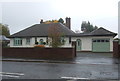

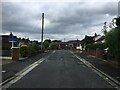
9
Magnolia Drive, Clayton-le-Woods
Looking north.
Image: © JThomas
Taken: 25 Oct 2018
0.16 miles