IMAGES TAKEN NEAR TO
Bradfield Close, LEYLAND, PR25 5PU
Introduction
This page details the photographs taken nearby to Bradfield Close, PR25 5PU by members of the Geograph project.
The Geograph project started in 2005 with the aim of publishing, organising and preserving representative images for every square kilometre of Great Britain, Ireland and the Isle of Man.

There are currently over 7.5m images from over14,400 individuals and you can help contribute to the project by visiting https://www.geograph.org.uk
Image Map
Images are licensed for reuse under creativecommons.org/licenses/by-sa/2.0
Notes
- Clicking on the map will re-center to the selected point.
- The higher the marker number, the further away the image location is from the centre of the postcode.
Image Listing (3 Images Found)
Images are licensed for reuse under creativecommons.org/licenses/by-sa/2.0
Image
Details
Distance
1
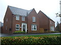
New housing off Wigan Road, Clayton-le-Woods
Image: © JThomas
Taken: 25 Oct 2018
0.16 miles

3
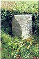
Old Milestone by the A49, near Clayton Woods
Carved stone post by the A49, in parish of CLAYTON LE WOODS (CHORLEY District), Cuerden Farm, by the road, on East side of road, in low hedge. Lancs. CC stone triangle, erected by the County Council in the 19th/20th century. Defaced.
Inscription once read:-
: (TO WIGAN / 12 / MILES) : : (TO / PRESTON / 5 MILES) :
Milestone Society National ID: LA_WGPS12.
Image: © J Higgins
Taken: 1 Oct 2008
0.20 miles