IMAGES TAKEN NEAR TO
Hatfield Drive, LEYLAND, PR25 5BB
Introduction
This page details the photographs taken nearby to Hatfield Drive, PR25 5BB by members of the Geograph project.
The Geograph project started in 2005 with the aim of publishing, organising and preserving representative images for every square kilometre of Great Britain, Ireland and the Isle of Man.

There are currently over 7.5m images from over14,400 individuals and you can help contribute to the project by visiting https://www.geograph.org.uk
Image Map
Images are licensed for reuse under creativecommons.org/licenses/by-sa/2.0
Notes
- Clicking on the map will re-center to the selected point.
- The higher the marker number, the further away the image location is from the centre of the postcode.
Image Listing (6 Images Found)
Images are licensed for reuse under creativecommons.org/licenses/by-sa/2.0
Image
Details
Distance
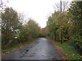

5
Lane junction
This is the junction of Nell Lane and Shady Lane. From this point Nell Lane leads down to the A49.
Image: © Ann Cook
Taken: 2 Nov 2006
0.23 miles
6
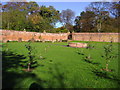
Walled garden
Near Cuerden Hall an old walled garden is being restored to its former glory.
Image: © Ann Cook
Taken: 2 Nov 2006
0.24 miles