IMAGES TAKEN NEAR TO
Knowsley Road, LEYLAND, PR25 4ZP
Introduction
This page details the photographs taken nearby to Knowsley Road, PR25 4ZP by members of the Geograph project.
The Geograph project started in 2005 with the aim of publishing, organising and preserving representative images for every square kilometre of Great Britain, Ireland and the Isle of Man.

There are currently over 7.5m images from over14,400 individuals and you can help contribute to the project by visiting https://www.geograph.org.uk
Image Map
Images are licensed for reuse under creativecommons.org/licenses/by-sa/2.0
Notes
- Clicking on the map will re-center to the selected point.
- The higher the marker number, the further away the image location is from the centre of the postcode.
Image Listing (42 Images Found)
Images are licensed for reuse under creativecommons.org/licenses/by-sa/2.0
Image
Details
Distance
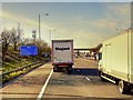
1
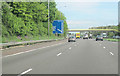
M6 north approaching Junction 28 at Leyland
Approaching footbridge over motorway
Image: © John Firth
Taken: 9 May 2012
0.04 miles
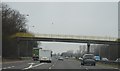
3
Footbridge over Southbound M6 near Leyland
Image: © David Dixon
Taken: 8 Apr 2015
0.09 miles
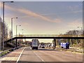
4
Leyland : M6 Motorway
The M6 Motorway between Junction 27 and Junction 28 (Holehouse).
Image: © Lewis Clarke
Taken: 23 Sep 2019
0.10 miles
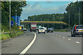
7
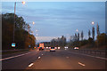
South Ribble : The M6 Motorway
Heading north through Lancashire on the M6 Motorway.
Image: © Lewis Clarke
Taken: 21 Apr 2016
0.15 miles
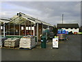
9
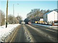
Passing Leyland Golf Club on the A49
Part of the golf club car park can be seen on the right.
Image: © Ann Cook
Taken: 20 Dec 2010
0.15 miles
10
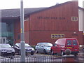
Clubhouse
Situated on the A49 at Leyland, this is the clubhouse for Leyland Golf Course.
Image: © Ann Cook
Taken: 1 Nov 2006
0.15 miles