IMAGES TAKEN NEAR TO
St. Annes Road, LEYLAND, PR25 4XS
Introduction
This page details the photographs taken nearby to St. Annes Road, PR25 4XS by members of the Geograph project.
The Geograph project started in 2005 with the aim of publishing, organising and preserving representative images for every square kilometre of Great Britain, Ireland and the Isle of Man.

There are currently over 7.5m images from over14,400 individuals and you can help contribute to the project by visiting https://www.geograph.org.uk
Image Map
Images are licensed for reuse under creativecommons.org/licenses/by-sa/2.0
Notes
- Clicking on the map will re-center to the selected point.
- The higher the marker number, the further away the image location is from the centre of the postcode.
Image Listing (10 Images Found)
Images are licensed for reuse under creativecommons.org/licenses/by-sa/2.0
Image
Details
Distance
1
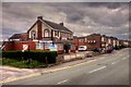
Farington & District Conservative Club, Stanifield Lane
Image: © David Dixon
Taken: 10 May 2015
0.10 miles
2
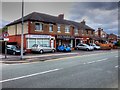
Shops on Stanifield Lane
Stanifield Lane (B5254), Farington.
Image: © David Dixon
Taken: 10 May 2015
0.12 miles
4
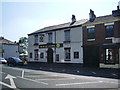
Rose & Crown, Stanifield Lane, Leyland
Image: © Alexander P Kapp
Taken: 13 May 2008
0.15 miles
6

St Catherine Laboure
Roman Catholic Church located just off Stanifield Lane Leyland, the building was in use when this image was taken, I do not know when it opened.
Image: © Steve Houldsworth
Taken: 9 Jan 2011
0.19 miles
9
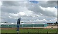
Armlee Nurseries
Large glasshouses at the nurseries
Image: © Eirian Evans
Taken: 12 May 2021
0.23 miles
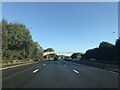
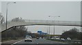
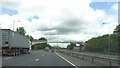
10
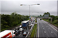
Major delays on the M6 between J27 and J20
Image: © Ian Greig
Taken: 8 Jun 2012
0.24 miles