IMAGES TAKEN NEAR TO
Victoria Terrace, LEYLAND, PR25 2FB
Introduction
This page details the photographs taken nearby to Victoria Terrace, PR25 2FB by members of the Geograph project.
The Geograph project started in 2005 with the aim of publishing, organising and preserving representative images for every square kilometre of Great Britain, Ireland and the Isle of Man.

There are currently over 7.5m images from over14,400 individuals and you can help contribute to the project by visiting https://www.geograph.org.uk
Image Map
Images are licensed for reuse under creativecommons.org/licenses/by-sa/2.0
Notes
- Clicking on the map will re-center to the selected point.
- The higher the marker number, the further away the image location is from the centre of the postcode.
Image Listing (120 Images Found)
Images are licensed for reuse under creativecommons.org/licenses/by-sa/2.0
Image
Details
Distance
2

Traffic lights at the junction of St. Andrew's Way and Church Road
Beyond the traffic lights is the old Elizabethan grammar school. It is now a museum.
Image: © Ann Cook
Taken: 4 Aug 2010
0.07 miles
5
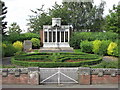
Leyland War Memorial
The War Memorial was built in 1929 after raising £1295 by public subscription. Interestingly, some of the men listed on the memorial died of Spanish Flu just a few weeks before the end of WW1. The names of the men who fell in the Second World War were added, with the unveiling ceremony being held on Sunday September 16th, 1951.
Image: © John Tustin
Taken: 8 Aug 2009
0.09 miles
6

Leyland War Memorial
The War Memorial in the memorial garden opposite St Andrew's Parish Church.
The War Memorial was built in 1929 after raising the £1295 required by public subscription. The names of the men who fell in the Second World War were added, with the unveiling ceremony being held on Sunday September 16th, 1951 (http://www.leylandhistoricalsociety.co.uk/lanes%2003.htm Leyland Historical Society).
Image: © David Dixon
Taken: 8 Jul 2012
0.09 miles
7

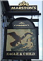
Eagle and Child, Leyland
The Eagle and Child public house on Church Road at Leyland.
Image: © David Dixon
Taken: 8 Jul 2012
0.09 miles
8
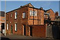
South Ribble Museum and Exhibition Centre
This old grammar school is on the east side of the parish church graveyard. It was restored by South Ribble District Council in 1977. See http://south-ribble.co.uk/srmuseum/pages/museum/museum.htm
Grade II Listed Building - see https://historicengland.org.uk/listing/the-list/list-entry/1361899
Image: © Ian Taylor
Taken: 13 Jan 2018
0.10 miles
9

War Memorial
This smaller memorial is sited next to the main War Memorial (Image]) in the memorial garden (Image]) opposite St Andrew's Church. It is dedicated to those who have lost their lives in conflicts after The Second World War.
Image: © David Dixon
Taken: 8 Jul 2012
0.10 miles
10
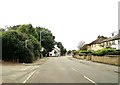
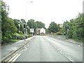
Church Road at the junction with Beech Avenue
The Eagle and Child is just ahead.
Image: © Ann Cook
Taken: 8 Sep 2012
0.10 miles