IMAGES TAKEN NEAR TO
Tomlinson Road, LEYLAND, PR25 2DS
Introduction
This page details the photographs taken nearby to Tomlinson Road, PR25 2DS by members of the Geograph project.
The Geograph project started in 2005 with the aim of publishing, organising and preserving representative images for every square kilometre of Great Britain, Ireland and the Isle of Man.

There are currently over 7.5m images from over14,400 individuals and you can help contribute to the project by visiting https://www.geograph.org.uk
Image Map
Images are licensed for reuse under creativecommons.org/licenses/by-sa/2.0
Notes
- Clicking on the map will re-center to the selected point.
- The higher the marker number, the further away the image location is from the centre of the postcode.
Image Listing (8 Images Found)
Images are licensed for reuse under creativecommons.org/licenses/by-sa/2.0
Image
Details
Distance

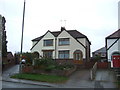
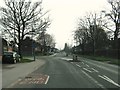
3
Junction of Golden Hill Lane and Braconash Road
Image: © Ann Cook
Taken: 19 Mar 2011
0.16 miles
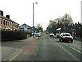
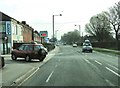
5
Mini-roundabout at the junction of Golden Hill Lane and Tomlinson Road
Image: © Ann Cook
Taken: 19 Mar 2011
0.18 miles
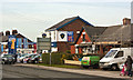
6
The entrance to Berry's on Golden Hill Lane
Berry's is a big timber, plumbing and builders merchants.
Image: © Ann Cook
Taken: 19 Mar 2011
0.18 miles
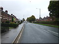
7
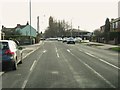
Golden Hill Lane at the junction with Cleveland Road
The traffic lights are at the junction with School Lane.
Image: © Ann Cook
Taken: 19 Mar 2011
0.23 miles