IMAGES TAKEN NEAR TO
PR25 1EG
Introduction
This page details the photographs taken nearby to PR25 1EG by members of the Geograph project.
The Geograph project started in 2005 with the aim of publishing, organising and preserving representative images for every square kilometre of Great Britain, Ireland and the Isle of Man.

There are currently over 7.5m images from over14,400 individuals and you can help contribute to the project by visiting https://www.geograph.org.uk
Image Map
Images are licensed for reuse under creativecommons.org/licenses/by-sa/2.0
Notes
- Clicking on the map will re-center to the selected point.
- The higher the marker number, the further away the image location is from the centre of the postcode.
Image Listing (9 Images Found)
Images are licensed for reuse under creativecommons.org/licenses/by-sa/2.0
Image
Details
Distance
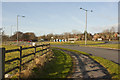
1
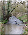
Shaw Brook
From the bridge on Shaw Brook Road
Image: © Gary Rogers
Taken: 18 Mar 2019
0.13 miles
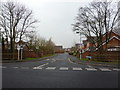
4
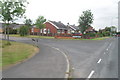
Junction of Leyland Lane & Lanchester Court
Image: © Anthony Parkes
Taken: 4 Jul 2010
0.18 miles
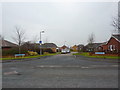
8
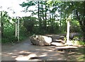
Back entrance to Worden Park
This large rock makes sure that drivers can't use this entrance to the park as a short cut.
Image: © Ann Cook
Taken: 2 Jun 2009
0.25 miles