IMAGES TAKEN NEAR TO
Oaktree Close, PRESTON, PR2 3UZ
Introduction
This page details the photographs taken nearby to Oaktree Close, PR2 3UZ by members of the Geograph project.
The Geograph project started in 2005 with the aim of publishing, organising and preserving representative images for every square kilometre of Great Britain, Ireland and the Isle of Man.

There are currently over 7.5m images from over14,400 individuals and you can help contribute to the project by visiting https://www.geograph.org.uk
Image Map
Images are licensed for reuse under creativecommons.org/licenses/by-sa/2.0
Notes
- Clicking on the map will re-center to the selected point.
- The higher the marker number, the further away the image location is from the centre of the postcode.
Image Listing (5 Images Found)
Images are licensed for reuse under creativecommons.org/licenses/by-sa/2.0
Image
Details
Distance

3
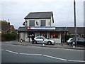
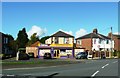
Ingol Off Licence
Also the Post Office and convenience store.
Image: © JThomas
Taken: 16 Nov 2013
0.19 miles
4
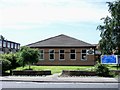
St Margaret, Ingol - Church of England
Founded in 1925 the building in this image was still in use when the picture was taken.
Image: © Steve Houldsworth
Taken: Unknown
0.21 miles
5

Tulketh Community Sports College (now closed)
Closed since 2008 - Sports facilities now being used as a 5-a-side football venture.
Image: © Anthony Parkes
Taken: 25 Oct 2014
0.25 miles