IMAGES TAKEN NEAR TO
Mayfield Avenue, PRESTON, PR2 3UH
Introduction
This page details the photographs taken nearby to Mayfield Avenue, PR2 3UH by members of the Geograph project.
The Geograph project started in 2005 with the aim of publishing, organising and preserving representative images for every square kilometre of Great Britain, Ireland and the Isle of Man.

There are currently over 7.5m images from over14,400 individuals and you can help contribute to the project by visiting https://www.geograph.org.uk
Image Map
Images are licensed for reuse under creativecommons.org/licenses/by-sa/2.0
Notes
- Clicking on the map will re-center to the selected point.
- The higher the marker number, the further away the image location is from the centre of the postcode.
Image Listing (13 Images Found)
Images are licensed for reuse under creativecommons.org/licenses/by-sa/2.0
Image
Details
Distance
1
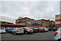
Tulketh Community Sports College (now closed)
Closed since 2008 - Sports facilities now being used as a 5-a-side football venture.
Image: © Anthony Parkes
Taken: 25 Oct 2014
0.11 miles
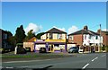
2
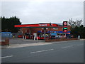
Ingol Off Licence
Also the Post Office and convenience store.
Image: © JThomas
Taken: 16 Nov 2013
0.15 miles
4
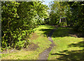
A footpath
It looks promising but doesn't go far, just shortcut to a nearby estate. Sharoe Brook is to the left but overgrown and all but invisible.
Image: © Ian Greig
Taken: 9 May 2014
0.17 miles
6
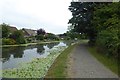
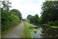
Bend in the canal
Looking along the Lancaster Canal near Bexhill Road in Preston.
Image: © DS Pugh
Taken: 23 Jul 2018
0.22 miles
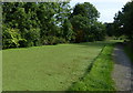
8
Lancaster Canal above Sharoe Brook
It's not obvious, but the canal is crossing a river on an aqueduct here.
Image: © DS Pugh
Taken: 23 Jul 2018
0.23 miles
9
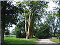
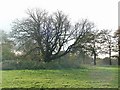
Tree Sculpture, Haslam Park, Ashton
Sculpted in the 21st century (I think). Haslam Park crosses the boundary of this square and SD5130 (see Image for a 20th century feature).
Image: © Dave Brown
Taken: 9 Jul 2005
0.24 miles