IMAGES TAKEN NEAR TO
Ingle Head, PRESTON, PR2 3NR
Introduction
This page details the photographs taken nearby to Ingle Head, PR2 3NR by members of the Geograph project.
The Geograph project started in 2005 with the aim of publishing, organising and preserving representative images for every square kilometre of Great Britain, Ireland and the Isle of Man.

There are currently over 7.5m images from over14,400 individuals and you can help contribute to the project by visiting https://www.geograph.org.uk
Image Map
Images are licensed for reuse under creativecommons.org/licenses/by-sa/2.0
Notes
- Clicking on the map will re-center to the selected point.
- The higher the marker number, the further away the image location is from the centre of the postcode.
Image Listing (6 Images Found)
Images are licensed for reuse under creativecommons.org/licenses/by-sa/2.0
Image
Details
Distance
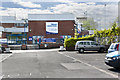
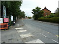
1
Fulwood Leisure Centre
Adjacent to Fulwood High School
Image: © David Medcalf
Taken: 13 Mar 2006
0.02 miles
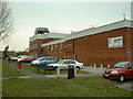
3
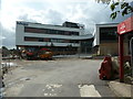
Fulwood Academy, Black Bull Lane, Fulwood
New school with the finishing touches to be done
Image: © Alexander P Kapp
Taken: 18 Sep 2012
0.08 miles