IMAGES TAKEN NEAR TO
Priors Lea Court, PRESTON, PR2 3NF
Introduction
This page details the photographs taken nearby to Priors Lea Court, PR2 3NF by members of the Geograph project.
The Geograph project started in 2005 with the aim of publishing, organising and preserving representative images for every square kilometre of Great Britain, Ireland and the Isle of Man.

There are currently over 7.5m images from over14,400 individuals and you can help contribute to the project by visiting https://www.geograph.org.uk
Image Map
Images are licensed for reuse under creativecommons.org/licenses/by-sa/2.0
Notes
- Clicking on the map will re-center to the selected point.
- The higher the marker number, the further away the image location is from the centre of the postcode.
Image Listing (16 Images Found)
Images are licensed for reuse under creativecommons.org/licenses/by-sa/2.0
Image
Details
Distance
1
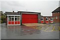
Fulwood fire station
Fulwood fire station, Garstang Road, Fulwood, Lancashire, forms part of the Lancashire Fire & Rescue Service Headquarters complex.
Image: © Kevin Hale
Taken: 22 Oct 2006
0.12 miles
3

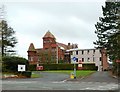
Lancashire Fire & Rescue Service HQ
Lancashire Fire & Rescue Service HQ, Garstang Road, Fulwood, Lancashire is house in this former country house.
Image: © Kevin Hale
Taken: 22 Oct 2006
0.13 miles
5

Lancashire Fire & Rescue Service HQ
The Service HQ building on Garstang Road, Fulwood was built as a private residence for one family but is now workplace for 187 people. Over many years it has become a compromise in terms of space and suitability for purpose. Moreover, the cost of maintaining and heating the old building has been a constant drain on resources which will be more than offset by the energy and efficiency savings that purpose-built premises would guarantee.
Lancashire’s Combined Fire Authority have approved plans to re-locate the Headquarters of the Lancashire Fire and Rescue Service from Fulwood to Chorley, building a new combined Service Headquarters and Training Centre site on the existing Chorley site, aiming for Spring of 2016 to complete the move.
Image: © Rude Health
Taken: 28 Jul 2013
0.14 miles
6
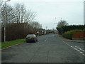
Lightfoot Lane, Fulwood
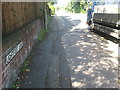
This used to be the major road into the Fylde from north Preston, but now replaced by a new road to service the housing estates of Tanterton and Ingol. Lightfoot Lane has been 'chopped off' - there is a dead end behind the photographer.
Image: © David Medcalf
Taken: 6 Feb 2006
0.15 miles

8
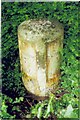
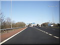
Old Milestone, A6, Garstang Road, near Junction with Eastway
The milestone is located by the north entrance to the County Fire HQ, on the west side of road by the roadside. Parish of Broughton (Preston District). Metal plates attached to stone post, Garstang flowing text design, erected by the Preston & Garstang turnpike trust in the 19th century.
Inscription reads:-
: To / Garstang / 7¾ / Miles : : BROUGHTON : : To / Preston / 3 / Miles :
Grade II listed.
List Entry Number: 1073566 https://historicengland.org.uk/listing/the-list/list-entry/1073566
Milestone Society National ID: LA_PSGS03
Image: © J Higgins
Taken: 1 May 2009
0.17 miles
9
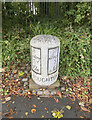
Old Milestone, A6, Garstang Road, near Junction with Eastway
The milestone is located by the north entrance to the County Fire HQ, on the west side of road by the roadside. Parish of Broughton (Preston District). Metal plates attached to stone post, Garstang flowing text design, erected by the Preston & Garstang turnpike trust in the 19th century. An earlier photograph can be found here https://www.geograph.org.uk/photo/6061155.
Inscription reads:-
To / Garstang / 7¾ / Miles : : BROUGHTON : : To / Preston / 3 / Miles
Grade II listed.
List Entry Number: 1073566 https://historicengland.org.uk/listing/the-list/list-entry/1073566
Milestone Society National ID: LA_PSGS03
Image: © Wayne MacDonald
Taken: 8 Oct 2020
0.17 miles