IMAGES TAKEN NEAR TO
Easterling Road, PRESTON, PR2 3DZ
Introduction
This page details the photographs taken nearby to Easterling Road, PR2 3DZ by members of the Geograph project.
The Geograph project started in 2005 with the aim of publishing, organising and preserving representative images for every square kilometre of Great Britain, Ireland and the Isle of Man.

There are currently over 7.5m images from over14,400 individuals and you can help contribute to the project by visiting https://www.geograph.org.uk
Image Map
Images are licensed for reuse under creativecommons.org/licenses/by-sa/2.0
Notes
- Clicking on the map will re-center to the selected point.
- The higher the marker number, the further away the image location is from the centre of the postcode.
Image Listing (7 Images Found)
Images are licensed for reuse under creativecommons.org/licenses/by-sa/2.0
Image
Details
Distance
4
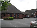
Fulwood Free Methodist Church
There used to be a farmhouse on this land, that was knocked down nearly 30 years ago and replaced with this church.
Won't be like this for long though, because the church is planning on an extension.
Image: © Graham Chastney
Taken: 15 Jul 2005
0.12 miles
6
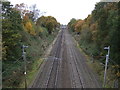
Railway heading north
West Coast Main Line towards Lancaster.
Image: © JThomas
Taken: 16 Nov 2013
0.18 miles