IMAGES TAKEN NEAR TO
Brackenbury Road, PRESTON, PR2 3BS
Introduction
This page details the photographs taken nearby to Brackenbury Road, PR2 3BS by members of the Geograph project.
The Geograph project started in 2005 with the aim of publishing, organising and preserving representative images for every square kilometre of Great Britain, Ireland and the Isle of Man.

There are currently over 7.5m images from over14,400 individuals and you can help contribute to the project by visiting https://www.geograph.org.uk
Image Map
Images are licensed for reuse under creativecommons.org/licenses/by-sa/2.0
Notes
- Clicking on the map will re-center to the selected point.
- The higher the marker number, the further away the image location is from the centre of the postcode.
Image Listing (17 Images Found)
Images are licensed for reuse under creativecommons.org/licenses/by-sa/2.0
Image
Details
Distance
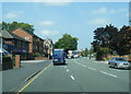
2
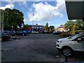
Traffic on the A6, Garstang Road, seen from a petrol station
Image: © Rob Purvis
Taken: 8 Aug 2016
0.06 miles
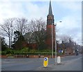
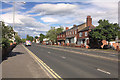
5
Fulwood Methodist Church
Fulwood Methodist Church is nearly 100 years old, built on land at the corner of Watling Street Road and Garstang Road purchased for the sum of £855. 51s 11d. The stone laying ceremony took place on 29th July 1911 and the church was opened and dedicated on 26th September 1912 by Rev F. L Wiseman, the President of the Methodist Conference. The total estimated cost of the entire project was £5,500, a tidy sum a century ago. The original debt of £2,500.00 was cleared in 1926 and the building of the Sunday School began on 5th May 1928, at an estimated cost of £3,500. It is this building, at the heart of Fulwood, that has now been re-developed.
The church has served the community in many ways down the years. During the First World War the congregation was swelled by soldiers from Fulwood Barracks and in the Second World War mothers and children from London and Manchester were evacuated to Fulwood and came to the church. The premises were used as a day school and later on a Library was established there by Lancashire County Council. During the 1940's the Guide and Scout groups were set up. Activities for young people have always been important including Youth and Fellowship Clubs and in the sixties a Mums & Toddlers' Group began, which still thrives today, meeting every Friday morning.
Image: © Rude Health
Taken: 28 Jul 2013
0.10 miles
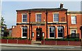
6
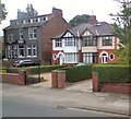
Whitburn House Hotel
And a pair of semi-detached houses on Garstang Road.
Image: © Gerald England
Taken: 4 Sep 2017
0.17 miles
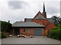
7
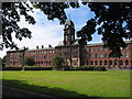
Preston Business Centre, University of Central Lancs
Now part of the University, before that it was a maternity hospital. I believe it was originally built in Victorian times as the "poor house". (To be accurate - the very right hand side crosses into square SD5431!)
Image: © Dave Brown
Taken: 17 Jul 2005
0.17 miles