IMAGES TAKEN NEAR TO
St. Michaels Close, PRESTON, PR2 3AY
Introduction
This page details the photographs taken nearby to St. Michaels Close, PR2 3AY by members of the Geograph project.
The Geograph project started in 2005 with the aim of publishing, organising and preserving representative images for every square kilometre of Great Britain, Ireland and the Isle of Man.

There are currently over 7.5m images from over14,400 individuals and you can help contribute to the project by visiting https://www.geograph.org.uk
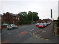
Image Map
Images are licensed for reuse under creativecommons.org/licenses/by-sa/2.0
Notes
- Clicking on the map will re-center to the selected point.
- The higher the marker number, the further away the image location is from the centre of the postcode.
Image Listing (12 Images Found)
Images are licensed for reuse under creativecommons.org/licenses/by-sa/2.0
Image
Details
Distance
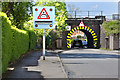
1
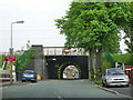
Nothing above 6ft 6in
Low bridge on Lytham Road, height restriction of 6ft 6in, the railway line is the London to Glasgow Line
Image: © Alexander P Kapp
Taken: 21 May 2008
0.06 miles
4
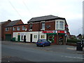
Convenience store
Spar Shop on Lytham Road.
Image: © JThomas
Taken: 16 Nov 2013
0.15 miles
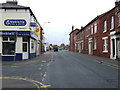
7
Plungington Road at the corner of Talbot Street
Image: © Rob Purvis
Taken: 27 Jun 2011
0.17 miles
8
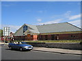
St Cuthbert's Church Centre, Lytham Road, Fulwood
Brand new church opened at Easter 05 on the site of the previous church (which was demolished the year before)
Image: © Dave Brown
Taken: 17 Jul 2005
0.18 miles
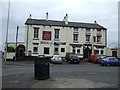
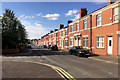
9
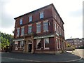
Cattle Market
This public house is all that remains of Preston Auction Market which was developed for housing.
Image: © Rude Health
Taken: 25 Aug 2013
0.19 miles