IMAGES TAKEN NEAR TO
Parkside, PRESTON, PR2 1YS
Introduction
This page details the photographs taken nearby to Parkside, PR2 1YS by members of the Geograph project.
The Geograph project started in 2005 with the aim of publishing, organising and preserving representative images for every square kilometre of Great Britain, Ireland and the Isle of Man.

There are currently over 7.5m images from over14,400 individuals and you can help contribute to the project by visiting https://www.geograph.org.uk
Image Map
Images are licensed for reuse under creativecommons.org/licenses/by-sa/2.0
Notes
- Clicking on the map will re-center to the selected point.
- The higher the marker number, the further away the image location is from the centre of the postcode.
Image Listing (18 Images Found)
Images are licensed for reuse under creativecommons.org/licenses/by-sa/2.0
Image
Details
Distance
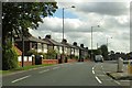
1
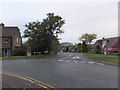
Avenue junction
The minor Tudor Avenue leads northward off Greenside Avenue in Lea.
Image: © Barbara Carr
Taken: 26 Oct 2013
0.07 miles
2
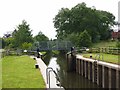
Lock 6, Ribble Link
The Ribble Link was a millennium project to link the Lancaster Canal with the Ribble estuary and thence with the rest of the English canal network. The towpath alongside forms part of the Guild Wheel cycle route which encircles Preston.
Image: © Oliver Dixon
Taken: 29 Jun 2013
0.10 miles
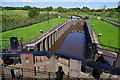
4
Lock 6 on the Millennium Ribble Link
It links the Ribble with the Lancaster Canal.
Image: © Bill Boaden
Taken: 18 Apr 2012
0.11 miles
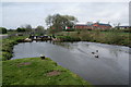
5
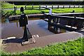
Lock 6, Ribble Link
Upper gates and paddles.
The mud (and bird tracks) in the foreground, on top of the lock chamber wall, shows that the water has risen to that level in recent flood conditions.
Image: © Ian Taylor
Taken: 26 Aug 2012
0.11 miles
6
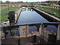
Lock No.6 Savick Brook
Lock number 6 on Savick Brook. Part of the Millennium Ribble Link
Image: © Peter Bainbridge
Taken: 3 Nov 2007
0.11 miles
7
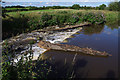
Lock 6 weir, Ribble Link
There was quite a flow in Savick Brook after recent rain.
Image: © Ian Taylor
Taken: 26 Aug 2012
0.12 miles
8
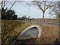
Bridge No. 7 over Savick Brook
Bridge over Savick Brook leading to Ashton and Lea Golf Course
Image: © Peter Bainbridge
Taken: 3 Nov 2007
0.12 miles
10
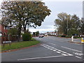
Junction of Tudor Avenue and the A5085
In Lea, a western suburb of Preston.
Image: © Barbara Carr
Taken: 26 Oct 2013
0.14 miles