IMAGES TAKEN NEAR TO
West Park Avenue, PRESTON, PR2 1SY
Introduction
This page details the photographs taken nearby to West Park Avenue, PR2 1SY by members of the Geograph project.
The Geograph project started in 2005 with the aim of publishing, organising and preserving representative images for every square kilometre of Great Britain, Ireland and the Isle of Man.

There are currently over 7.5m images from over14,400 individuals and you can help contribute to the project by visiting https://www.geograph.org.uk
Image Map
Images are licensed for reuse under creativecommons.org/licenses/by-sa/2.0
Notes
- Clicking on the map will re-center to the selected point.
- The higher the marker number, the further away the image location is from the centre of the postcode.
Image Listing (52 Images Found)
Images are licensed for reuse under creativecommons.org/licenses/by-sa/2.0
Image
Details
Distance

3
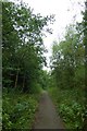
Path beside Tom Benson Way
Looking along a path below the road.
Image: © DS Pugh
Taken: 23 Jul 2018
0.09 miles
4
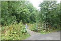
Path towards Millennium Ribble Link
This path leads through to the locks at the canal junction.
Image: © DS Pugh
Taken: 23 Jul 2018
0.12 miles
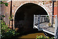
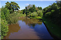
5
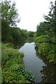
Canal near the rail bridge
Looking along the Ribble Link from the tunnel under the rail bridge.
Image: © DS Pugh
Taken: 23 Jul 2018
0.12 miles
6
Basin below the lock flight
Part of the Millennium Ribble Link.
Image: © DS Pugh
Taken: 23 Jul 2018
0.12 miles
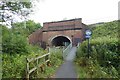
7
Bridge 4, Ribble Link
This bridge carries the Preston to Blackpool railway line over Savick Brook.
An elevated walkway was built to carry the footpath which follows the Ribble Link.
Image: © Ian Taylor
Taken: 26 Aug 2012
0.12 miles
8
Rail bridge over Ribble Link
Looking towards a bridge over the Ribble Link canal.
Image: © DS Pugh
Taken: 23 Jul 2018
0.12 miles

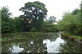
10
Savick Brook
The brook flows into this basin at the far end, and flows out to the right in the foreground.
Boats navigating the Ribble Link have to turn through about 120° here, but due to limited space, this effectively requires a reversal of direction. See Image for a view in the opposite direction.
Image: © Ian Taylor
Taken: 26 Aug 2012
0.12 miles