IMAGES TAKEN NEAR TO
Summertrees Avenue, PRESTON, PR2 1SA
Introduction
This page details the photographs taken nearby to Summertrees Avenue, PR2 1SA by members of the Geograph project.
The Geograph project started in 2005 with the aim of publishing, organising and preserving representative images for every square kilometre of Great Britain, Ireland and the Isle of Man.

There are currently over 7.5m images from over14,400 individuals and you can help contribute to the project by visiting https://www.geograph.org.uk
Image Map
Images are licensed for reuse under creativecommons.org/licenses/by-sa/2.0
Notes
- Clicking on the map will re-center to the selected point.
- The higher the marker number, the further away the image location is from the centre of the postcode.
Image Listing (17 Images Found)
Images are licensed for reuse under creativecommons.org/licenses/by-sa/2.0
Image
Details
Distance
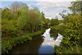
2
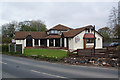
The Coty Brook
A modern pub built in 1990 to serve a new housing estate nearby.
Image: © Keith Wright
Taken: 19 Dec 2005
0.16 miles
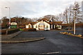
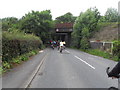
4
Vacant pub to let
The former Cotty Brook is now standing empty. This was quite a new pub. The railway from Preston to Blackpool runs behind it.
Image: © Bill Boaden
Taken: 18 Apr 2012
0.17 miles

7
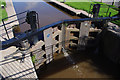
Lock 5, Ribble Link
Gates built by British Waterways at Northwich in 2001. Although the gates are mostly steel, wood is still used to provide a good but not perfect water seal.
Image: © Ian Taylor
Taken: 26 Aug 2012
0.20 miles
8
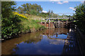
Lock 5, Ribble Link
Footbridge and lower gates from the mooring platform below the lock.
Image: © Ian Taylor
Taken: 26 Aug 2012
0.20 miles
9
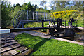
Lock 5, Ribble Link
Footbridge and lower gates.
Image: © Ian Taylor
Taken: 26 Aug 2012
0.20 miles