IMAGES TAKEN NEAR TO
Blackthorn Close, PRESTON, PR2 1RH
Introduction
This page details the photographs taken nearby to Blackthorn Close, PR2 1RH by members of the Geograph project.
The Geograph project started in 2005 with the aim of publishing, organising and preserving representative images for every square kilometre of Great Britain, Ireland and the Isle of Man.

There are currently over 7.5m images from over14,400 individuals and you can help contribute to the project by visiting https://www.geograph.org.uk
Image Map
Images are licensed for reuse under creativecommons.org/licenses/by-sa/2.0
Notes
- Clicking on the map will re-center to the selected point.
- The higher the marker number, the further away the image location is from the centre of the postcode.
Image Listing (18 Images Found)
Images are licensed for reuse under creativecommons.org/licenses/by-sa/2.0
Image
Details
Distance
1
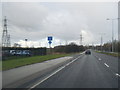
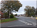
New housing development north of the A584
Along with many cities, Preston has a need to increase the housing supply.
Image: © Bill Boaden
Taken: 18 Apr 2012
0.13 miles
4
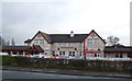
The Pig & Whistle
Off Blackpool Road (A583).
Image: © JThomas
Taken: 15 Nov 2014
0.18 miles
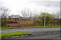
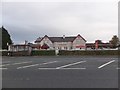
7
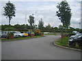
Garden Centre Car Park
Car Park for a large shop near Preston
Image: © Michael Graham
Taken: 27 Aug 2009
0.19 miles
8
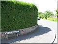
Junction of Tudor Avenue and the A5085
In Lea, a western suburb of Preston.
Image: © Barbara Carr
Taken: 26 Oct 2013
0.19 miles
9
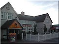
The Pig and Whistle, Lea
Public house on the A5805.
Image: © Barbara Carr
Taken: 26 Oct 2013
0.20 miles