
IMAGES TAKEN NEAR TO
Whinfield Place, PRESTON, PR2 1NR
Introduction
This page details the photographs taken nearby to Whinfield Place, PR2 1NR by members of the Geograph project.
The Geograph project started in 2005 with the aim of publishing, organising and preserving representative images for every square kilometre of Great Britain, Ireland and the Isle of Man.

There are currently over 7.5m images from over14,400 individuals and you can help contribute to the project by visiting https://www.geograph.org.uk
Image Map
Images are licensed for reuse under creativecommons.org/licenses/by-sa/2.0
Notes
- Clicking on the map will re-center to the selected point.
- The higher the marker number, the further away the image location is from the centre of the postcode.
Image Listing (31 Images Found)
Images are licensed for reuse under creativecommons.org/licenses/by-sa/2.0
Image
Details
Distance
3

Ashton Park
It has wide open spaces and the raindrop in the middle of my lens is perhaps evidence of this. The large house to the right is now occupied by some form of educational nursery.
Image: © Bill Boaden
Taken: 18 Apr 2012
0.15 miles
5
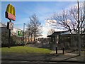
The edge of Ashton Park
The eastern side adjoining Pedders Lane.
Image: © Bill Boaden
Taken: 18 Apr 2012
0.17 miles
8
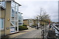
Commercial units opposite Preston Marina
Several are being used, but it is far from 100% occupancy.
Image: © Bill Boaden
Taken: 18 Apr 2012
0.18 miles
9
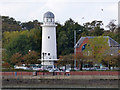
Lighthouse at Albert Edward Dock
The replica lighthouse was built in 1986, long after the dock closed to shipping. It was built by Morrison's to guide shoppers to their new supermarket and also to mark Preston's maritime past.
See also Image
Image: © Thomas Nugent
Taken: 19 Oct 2018
0.19 miles
10
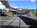
Tar refinery, Preston Docklands
The Lanfina tar refinery at the north-west corner of the Preston Dock estate still receives its bitumen by rail, worked through the docklands by the private Ribble Steam Railway (RSR). At one time a railway siding used to extend right into the works and the remains of this are seen here crossing Chain Caul Way. Today, however, a new siding has been provided closer to the RSR and the bitumen is transferred from the rail wagons into the works by pipeline along the overhead gantry.
Image: © A-M-Jervis
Taken: 12 Aug 2007
0.20 miles