IMAGES TAKEN NEAR TO
Mayfield Road, PRESTON, PR2 1EX
Introduction
This page details the photographs taken nearby to Mayfield Road, PR2 1EX by members of the Geograph project.
The Geograph project started in 2005 with the aim of publishing, organising and preserving representative images for every square kilometre of Great Britain, Ireland and the Isle of Man.

There are currently over 7.5m images from over14,400 individuals and you can help contribute to the project by visiting https://www.geograph.org.uk
Image Map
Images are licensed for reuse under creativecommons.org/licenses/by-sa/2.0
Notes
- Clicking on the map will re-center to the selected point.
- The higher the marker number, the further away the image location is from the centre of the postcode.
Image Listing (11 Images Found)
Images are licensed for reuse under creativecommons.org/licenses/by-sa/2.0
Image
Details
Distance
2
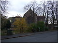
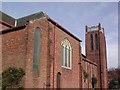
St Michael's & All Angels Church
On Egerton Road.
Image: © JThomas
Taken: 15 Nov 2014
0.10 miles
3
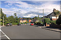
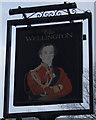
Tulketh Road (the A5072)
From the junction with Egerton Road. The church on the left is that of St Michael and All Angels, and the street to the right is Wellington road.
Image: © Barbara Carr
Taken: 13 Nov 2013
0.12 miles
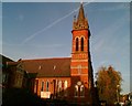
5
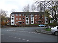
Church of the Sacred Heart
Church on the corner of Newton Road and Beech Grove
Image: © Peter Bainbridge
Taken: 4 Nov 2007
0.15 miles
6
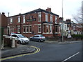
Waterloo Terrace
In the western suburbs of Preston, north of the A5072.
Image: © Barbara Carr
Taken: 13 Nov 2013
0.20 miles
10
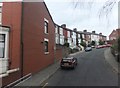
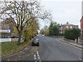
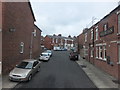
Poulton Street
To the northeast of Tulketh Road (the A5072).
Image: © Barbara Carr
Taken: 13 Nov 2013
0.22 miles