IMAGES TAKEN NEAR TO
Winmarleigh Road, PRESTON, PR2 1ET
Introduction
This page details the photographs taken nearby to Winmarleigh Road, PR2 1ET by members of the Geograph project.
The Geograph project started in 2005 with the aim of publishing, organising and preserving representative images for every square kilometre of Great Britain, Ireland and the Isle of Man.

There are currently over 7.5m images from over14,400 individuals and you can help contribute to the project by visiting https://www.geograph.org.uk
Image Map
Images are licensed for reuse under creativecommons.org/licenses/by-sa/2.0
Notes
- Clicking on the map will re-center to the selected point.
- The higher the marker number, the further away the image location is from the centre of the postcode.
Image Listing (19 Images Found)
Images are licensed for reuse under creativecommons.org/licenses/by-sa/2.0
Image
Details
Distance
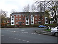
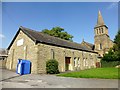
2
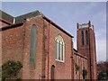
Church of the Sacred Heart
Church on the corner of Newton Road and Beech Grove
Image: © Peter Bainbridge
Taken: 4 Nov 2007
0.11 miles
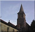
3
St Michael's & All Angels Church
On Egerton Road.
Image: © JThomas
Taken: 15 Nov 2014
0.13 miles
4
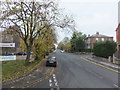
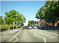
Tulketh Road (the A5072)
From the junction with Egerton Road. The church on the left is that of St Michael and All Angels, and the street to the right is Wellington road.
Image: © Barbara Carr
Taken: 13 Nov 2013
0.15 miles
6
St. Andrew's Church
Church on Blackpool Road near to the junction with Tulketh Road
Image: © Peter Bainbridge
Taken: 4 Nov 2007
0.20 miles
7
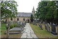
St. Andrew's Church
Looking across the Churchyard from Blackpool Road.
Image: © DS Pugh
Taken: 21 Jul 2018
0.20 miles
8
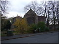
St Andrew's Church, Ashton-on-Ribble
St Andrew's was built in 1836. In 1873–74 the architect Ewan Christian added a north aisle and converted the nave windows into Early English style. A vestry was added in 1902. The church is designated by English Heritage as a Grade II listed building.
The church is constructed in sandstone with slate roofs. Its plan consists of a four-bay nave, a wide north aisle, a north porch, a chancel with an organ chamber to the north, a vestry to the east, and a small west tower. The tower is in Romanesque style, and the rest of the church is in Early English style. The tower is in three stages, with buttresses, and a short broach spire. In the bottom stage are two round-headed lancet windows, with a similar but larger window in the middle stage. The bell openings are louvred, and consist of triple round-headed lancets. Along the sides of the nave and the aisle are three two-light windows, and a three-light window in the eastern bay.
Image: © Rude Health
Taken: 26 Aug 2013
0.20 miles
9
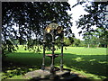
Drinking Water Fountain, Haslam Park, Ashton
This fountain was gifted to the park in 1911 - it's no longer in use as a drinking fountain. Haslam Park covers this square and SD5131. (See Image for a 21st century sculpture).
Image: © Dave Brown
Taken: 9 Jul 2005
0.21 miles