IMAGES TAKEN NEAR TO
Ashton Bank Way, PRESTON, PR2 1BF
Introduction
This page details the photographs taken nearby to Ashton Bank Way, PR2 1BF by members of the Geograph project.
The Geograph project started in 2005 with the aim of publishing, organising and preserving representative images for every square kilometre of Great Britain, Ireland and the Isle of Man.

There are currently over 7.5m images from over14,400 individuals and you can help contribute to the project by visiting https://www.geograph.org.uk
Image Map
Images are licensed for reuse under creativecommons.org/licenses/by-sa/2.0
Notes
- Clicking on the map will re-center to the selected point.
- The higher the marker number, the further away the image location is from the centre of the postcode.
Image Listing (17 Images Found)
Images are licensed for reuse under creativecommons.org/licenses/by-sa/2.0
Image
Details
Distance
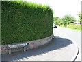
2
#66 Thurnham Road
There is an OS benchmark Image on the near corner, right hand face, of the house, left of the black downpipe
Image: © Roger Templeman
Taken: 2 Jul 2016
0.07 miles
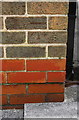
3
Benchmark on #66 Thurnham Road
Ordnance Survey cut mark benchmark described on the Bench Mark Database at http://www.bench-marks.org.uk/bm76729
Image: © Roger Templeman
Taken: 2 Jul 2016
0.07 miles
4
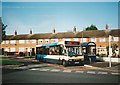
Bus in turning circle, Larches estate
Preston Bus 81, an Optare Solo M920 new earlier the same year, lays over at the terminus of route 27 on Larches Lane before returning to Preston city centre.
Image: © Richard Vince
Taken: 23 Sep 2006
0.09 miles
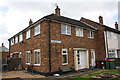
6
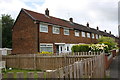
Houses on Ryelands Crescent
There is an OS benchmark Image on the corner, left hand face, of the nearest house
Image: © Roger Templeman
Taken: 2 Jul 2016
0.16 miles
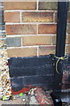
8
Benchmark on #33 Ryelands Crescent
Ordnance Survey cut mark benchmark described on the Bench Mark Database at http://www.bench-marks.org.uk/bm76730
Image: © Roger Templeman
Taken: 2 Jul 2016
0.17 miles
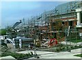
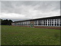
10
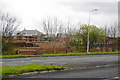
New housing development north of the A584
Along with many cities, Preston has a need to increase the housing supply.
Image: © Bill Boaden
Taken: 18 Apr 2012
0.20 miles